Sestu night lights from space
Night Light of Sestu (Sardinia) from space (Italy) Src. Average luminocity for 10x10km area is 50.4116% and for 50x50km: 14.9167%.
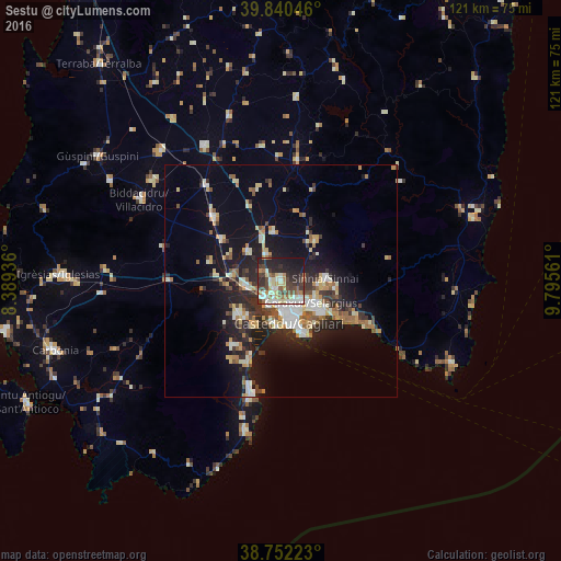
Analysis of Sestu night lights 2016
Square area 10x10 km:
 6.8%
6.8%90-99
11.05%80-89
9.86%70-79
2.04%60-69
8.84%50-59
4.25%40-49
10.54%30-39
11.22%20-29
18.03%10-19
16.84%0-9
0.51%Square area 50x50 km:
1.67%90-99
2.75%80-89
1.94%70-79
1.72%60-69
2.05%50-59
1.45%40-49
1.74%30-39
2.29%20-29
4.81%10-19
10.98%0-9
68.6%Clear (daylight) street map image can be seen on geolist.org.
Map coordinates:
39° 50' 25.7" North, 8° 23' 21.7" East
39° 17' 54.5" North, 9° 5' 32.9" East
38° 45' 8" North, 9° 47' 44.2" East
Some cities around Sestu sort by population:
• Cagliari
7.9 km =4.9 mi,  163°
163°
• Assemini
8.1 km =5 mi,  264°
264°
• Selargius
7.6 km =4.7 mi,  126°
126°
• Monserrato
6.5 km =4 mi,  136°
136°
• Sinnai
9.5 km =5.9 mi,  87°
87°
• Quartucciu
8.9 km =5.5 mi,  124°
124°
• Elmas
4.9 km =3 mi,  227°
227°
• Settimo San Pietro
8.1 km =5 mi,  95°
95°
2523136 (p: 18,191)
Sources (retrieved 2019-11-25):
» Earth at Night: Flat Maps 2012, 2016