Elmas night lights from space
Night Light of Elmas (Sardinia) from space (Italy) Src. Average luminocity for 10x10km area is 59.8878% and for 50x50km: 14.9461%.
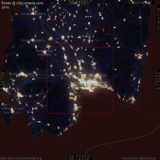
Analysis of Elmas night lights 2016
Square area 10x10 km:
100  10.2%
10.2%
90-99 14.12%
80-89 11.39%
70-79 5.1%
60-69 7.82%
50-59 5.61%
40-49 11.22%
30-39 11.39%
20-29 23.13%
10-19 0%
0-9 0%
10.2%90-99
14.12%80-89
11.39%70-79
5.1%60-69
7.82%50-59
5.61%40-49
11.22%30-39
11.39%20-29
23.13%10-19
0%0-9
0%Square area 50x50 km:
100 1.7%
90-99 2.78%
80-89 2%
70-79 1.66%
60-69 2.01%
50-59 1.47%
40-49 1.78%
30-39 2.28%
20-29 4.86%
10-19 11.41%
0-9 68.06%
1.7%90-99
2.78%80-89
2%70-79
1.66%60-69
2.01%50-59
1.47%40-49
1.78%30-39
2.28%20-29
4.86%10-19
11.41%0-9
68.06%Clear (daylight) street map image can be seen on geolist.org.
Map coordinates:
39° 48' 39.6" North, 8° 20' 49.5" East
39° 16' 7.6" North, 9° 3' 0.8" East
38° 43' 20.4" North, 9° 45' 12" East
Some cities around Elmas sort by population:
• Cagliari
7.3 km =4.5 mi,  125°
125°
• Assemini
5.1 km =3.2 mi,  299°
299°
• Selargius
9.8 km =6.1 mi,  97°
97°
• Monserrato
8.2 km =5.1 mi, 99°
• Sestu
4.9 km =3 mi,  47°
47°
• Decimomannu
8.3 km =5.2 mi, 303°
• San Sperate
10.5 km =6.5 mi,  339°
339°
• Uta
8.8 km =5.5 mi,  286°
286°
2524820 (p: 8,025)
Sources (retrieved 2019-11-25):
» Earth at Night: Flat Maps 2012, 2016