Sant'Angelo di Piove di Sacco night lights from space
Night Light of Sant'Angelo di Piove di Sacco (Veneto) from space (Italy) Src. Average luminocity for 10x10km area is 53.3651% and for 50x50km: 42.4159%.
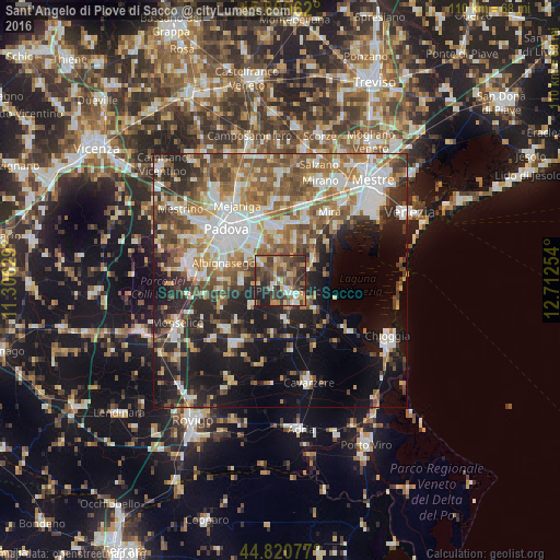
Analysis of Sant'Angelo di Piove di Sacco night lights 2016
Square area 10x10 km:
 4.44%
4.44%90-99
7.3%80-89
6.83%70-79
9.21%60-69
7.94%50-59
10.79%40-49
19.05%30-39
15.71%20-29
14.76%10-19
3.97%0-9
0%Square area 50x50 km:
7.79%90-99
8.72%80-89
3.86%70-79
4.82%60-69
6.92%50-59
8.07%40-49
6.98%30-39
5.9%20-29
9.61%10-19
15.03%0-9
22.28%Clear (daylight) street map image can be seen on geolist.org.
Map coordinates:
45° 48' 34.6" North, 11° 18' 22.6" East
45° 19' 2.5" North, 12° 0' 33.9" East
44° 49' 14.8" North, 12° 42' 45.1" East
Some cities around Sant'Angelo di Piove di Sacco sort by population:
• Piove di Sacco-Piovega
3.1 km =1.9 mi,  137°
137°
• Ponte San Nicolò
8.7 km =5.4 mi,  309°
309°
• Camponogara
9.2 km =5.7 mi,  41°
41°
• Legnaro
4.5 km =2.8 mi, 308°
• Stra
10.4 km =6.5 mi,  2°
2°
• Villatora
8.5 km =5.3 mi,  337°
337°
• Maserà di Padova
11.3 km =7 mi,  270°
270°
• Fossò
8.1 km =5 mi,  20°
20°
3167448 (p: 6,128)
Sources (retrieved 2019-11-25):
» Earth at Night: Flat Maps 2012, 2016