Ponte San Nicolò night lights from space
Night Light of Ponte San Nicolò (Veneto) from space (Italy) Src. Average luminocity for 10x10km area is 79.4016% and for 50x50km: 45.6937%.
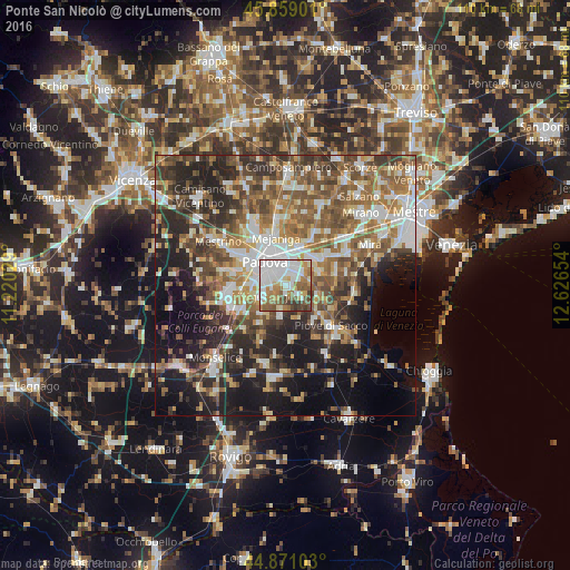
Analysis of Ponte San Nicolò night lights 2016
Square area 10x10 km:
 26.35%
90-99
23.33%80-89
5.4%70-79
7.94%60-69
12.06%50-59
13.49%40-49
6.67%30-39
4.44%20-29
0.32%10-19
0%0-9
0%Square area 50x50 km:
7.32%90-99
8.99%80-89
4.36%70-79
5.33%60-69
7.63%50-59
9.6%40-49
8.88%30-39
6.99%20-29
11.67%10-19
14.69%0-9
14.53%Clear (daylight) street map image can be seen on geolist.org.
Map coordinates:
45° 51' 32.4" North, 11° 13' 13" East
45° 22' 1.8" North, 11° 55' 24.3" East
44° 52' 15.7" North, 12° 37' 35.5" East
Some cities around Ponte San Nicolò sort by population:
• Padova
5.4 km =3.4 mi,  327°
327°
• Albignasego
4.9 km =3 mi,  242°
242°
• Vigonza
8.5 km =5.3 mi,  28°
28°
• Noventa
5.7 km =3.5 mi,  22°
22°
• Legnaro
4.3 km =2.7 mi,  130°
130°
• Villatora
4.1 km =2.5 mi,  56°
56°
• Mandriola-Sant'Agostino
5.7 km =3.5 mi,  272°
272°
• Maserà di Padova
7.1 km =4.4 mi,  219°
219°
3170220 (p: 12,180)
Sources (retrieved 2019-11-25):
» Earth at Night: Flat Maps 2012, 2016