Sant'Ambrogio di Valpollicella night lights from space
Night Light of Sant'Ambrogio di Valpollicella (Veneto) from space (Italy) Src. Average luminocity for 10x10km area is 56.3015% and for 50x50km: 31.0143%.
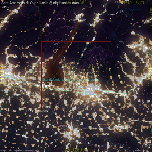
Analysis of Sant'Ambrogio di Valpollicella night lights 2016
Square area 10x10 km:
 4.55%
4.55%90-99
11.52%80-89
9.09%70-79
8.18%60-69
7.42%50-59
14.09%40-49
15%30-39
11.67%20-29
12.58%10-19
5.91%0-9
0%Square area 50x50 km:
4.66%90-99
5.45%80-89
2.82%70-79
3.35%60-69
5%50-59
5.55%40-49
5.39%30-39
5.5%20-29
12.79%10-19
13.13%0-9
36.37%Clear (daylight) street map image can be seen on geolist.org.
Map coordinates:
46° 0' 41" North, 10° 7' 59" East
45° 31' 15.2" North, 10° 50' 10.2" East
45° 1' 33.9" North, 11° 32' 21.5" East
Some cities around Sant'Ambrogio di Valpollicella sort by population:
• Bussolengo
5.9 km =3.7 mi,  166°
166°
• Pescantina
4.7 km =2.9 mi,  147°
147°
• Lugagnano
10.4 km =6.5 mi,  159°
159°
• Sommacampagna
12.9 km =8 mi,  177°
177°
• Negrar
8.1 km =5 mi,  83°
83°
• San Pietro in Cariano
3.9 km =2.4 mi,  95°
95°
• Castelnuovo del Garda
10.9 km =6.8 mi,  213°
213°
• Arbizzano-Santa Maria
8.5 km =5.3 mi,  109°
109°
3167513 (p: 10,384)
Sources (retrieved 2019-11-25):
» Earth at Night: Flat Maps 2012, 2016