Sandrigo night lights from space
Night Light of Sandrigo (Veneto) from space (Italy) Src. Average luminocity for 10x10km area is 50.7061% and for 50x50km: 41.2313%.
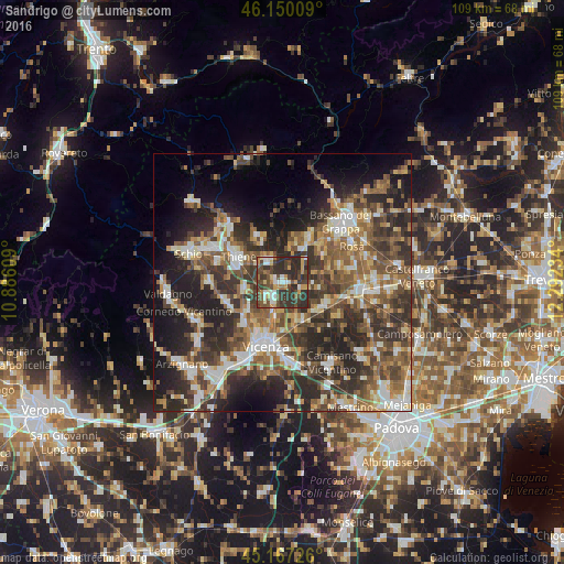
Analysis of Sandrigo night lights 2016
Square area 10x10 km:
 4.7%
4.7%90-99
9.7%80-89
3.94%70-79
8.18%60-69
4.7%50-59
5.91%40-49
18.03%30-39
18.79%20-29
26.06%10-19
0%0-9
0%Square area 50x50 km:
4.88%90-99
7.12%80-89
4.2%70-79
4.73%60-69
6.27%50-59
8.93%40-49
9.2%30-39
10.02%20-29
14.92%10-19
12.4%0-9
17.34%Clear (daylight) street map image can be seen on geolist.org.
Map coordinates:
46° 9' 0.3" North, 10° 53' 9.9" East
45° 39' 39" North, 11° 35' 21.2" East
45° 10' 2.1" North, 12° 17' 32.4" East
Some cities around Sandrigo sort by population:
• Thiene
10 km =6.2 mi,  302°
302°
• Dueville
4.1 km =2.5 mi,  226°
226°
• Caldogno-Rettorgole-Cresole
8.9 km =5.5 mi, 228°
• Marostica
11 km =6.8 mi,  31°
31°
• Marano Vicentino
12.8 km =8 mi,  287°
287°
• Monticello Conte Otto
7.1 km =4.4 mi,  190°
190°
• Carmignano di Brenta
9.9 km =6.2 mi,  113°
113°
• Breganze
5.4 km =3.4 mi,  335°
335°
3168407 (p: 6,333)
Sources (retrieved 2019-11-25):
» Earth at Night: Flat Maps 2012, 2016