Carmignano di Brenta night lights from space
Night Light of Carmignano di Brenta (Veneto) from space (Italy) Src. Average luminocity for 10x10km area is 49.6212% and for 50x50km: 48.2544%.
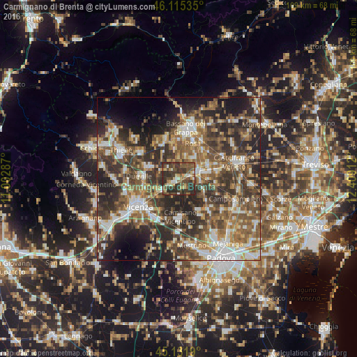
Analysis of Carmignano di Brenta night lights 2016
Square area 10x10 km:
 2.27%
2.27%90-99
5.76%80-89
7.12%70-79
5.15%60-69
6.06%50-59
13.94%40-49
16.67%30-39
24.7%20-29
18.33%10-19
0%0-9
0%Square area 50x50 km:
6.22%90-99
8.82%80-89
4.58%70-79
5.89%60-69
7.47%50-59
11.41%40-49
11.23%30-39
11.12%20-29
15.61%10-19
9.19%0-9
8.45%Clear (daylight) street map image can be seen on geolist.org.
Map coordinates:
46° 6' 55.3" North, 11° 0' 10.3" East
45° 37' 32.8" North, 11° 42' 21.6" East
45° 7' 54.8" North, 12° 24' 32.8" East
Some cities around Carmignano di Brenta sort by population:
• Cittadella
6.5 km =4 mi,  70°
70°
• Rosà
9.5 km =5.9 mi,  26°
26°
• Tombolo
9.3 km =5.8 mi,  80°
80°
• Monticello Conte Otto
10.8 km =6.7 mi,  253°
253°
• Belvedere
8.8 km =5.5 mi,  35°
35°
• Galliera Veneta
10.2 km =6.3 mi,  62°
62°
• Sandrigo
9.9 km =6.2 mi,  293°
293°
• Fontaniva
3.9 km =2.4 mi, 74°
3180491 (p: 6,295)
Sources (retrieved 2019-11-25):
» Earth at Night: Flat Maps 2012, 2016