Monticello Conte Otto night lights from space
Night Light of Monticello Conte Otto (Veneto) from space (Italy) Src. Average luminocity for 10x10km area is 62.9091% and for 50x50km: 45.3814%.
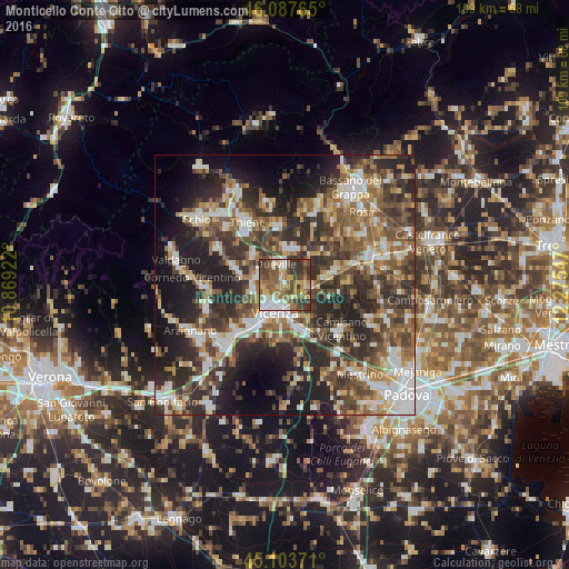
Analysis of Monticello Conte Otto night lights 2016
Square area 10x10 km:
 9.7%
9.7%90-99
11.21%80-89
8.48%70-79
8.18%60-69
11.82%50-59
16.97%40-49
11.82%30-39
18.18%20-29
3.64%10-19
0%0-9
0%Square area 50x50 km:
6.12%90-99
8.5%80-89
4.65%70-79
5.09%60-69
6.39%50-59
9.09%40-49
9.8%30-39
10.37%20-29
16.09%10-19
13.65%0-9
10.24%Clear (daylight) street map image can be seen on geolist.org.
Map coordinates:
46° 5' 15.5" North, 10° 52' 9.2" East
45° 35' 52.2" North, 11° 34' 20.4" East
45° 6' 13.4" North, 12° 16' 31.7" East
Some cities around Monticello Conte Otto sort by population:
• Vicenza
6 km =3.7 mi,  198°
198°
• Dueville
4.5 km =2.8 mi,  338°
338°
• Caldogno-Rettorgole-Cresole
5.5 km =3.4 mi,  281°
281°
• Creazzo
10.4 km =6.5 mi,  224°
224°
• Torri di Quartesolo
9.7 km =6 mi,  155°
155°
• Sandrigo
7.1 km =4.4 mi,  10°
10°
• Carmignano di Brenta
10.8 km =6.7 mi,  73°
73°
• Breganze
11.9 km =7.4 mi,  355°
355°
3172682 (p: 7,361)
Sources (retrieved 2019-11-25):
» Earth at Night: Flat Maps 2012, 2016