Breganze night lights from space
Night Light of Breganze (Veneto) from space (Italy) Src. Average luminocity for 10x10km area is 45.0803% and for 50x50km: 35.3011%.
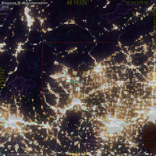
Analysis of Breganze night lights 2016
Square area 10x10 km:
 3.03%
3.03%90-99
5.61%80-89
3.79%70-79
6.67%60-69
8.18%50-59
6.21%40-49
15.3%30-39
14.09%20-29
26.52%10-19
10.61%0-9
0%Square area 50x50 km:
4.08%90-99
6.09%80-89
3.59%70-79
3.84%60-69
5.24%50-59
7.9%40-49
7.97%30-39
8.6%20-29
12.44%10-19
10.91%0-9
29.35%Clear (daylight) street map image can be seen on geolist.org.
Map coordinates:
46° 11' 37.5" North, 10° 51' 27.4" East
45° 42' 17.6" North, 11° 33' 38.7" East
45° 12' 42.1" North, 12° 15' 49.9" East
Some cities around Breganze sort by population:
• Thiene
6.3 km =3.9 mi,  273°
273°
• Dueville
7.7 km =4.8 mi,  185°
185°
• Caldogno-Rettorgole-Cresole
11.7 km =7.3 mi,  202°
202°
• Marostica
9.1 km =5.7 mi,  60°
60°
• Marano Vicentino
10 km =6.2 mi,  264°
264°
• Piovene Rocchette
11.4 km =7.1 mi,  299°
299°
• Zanè
8.9 km =5.5 mi,  282°
282°
• Sandrigo
5.4 km =3.4 mi,  155°
155°
3181583 (p: 5,470)
Sources (retrieved 2019-11-25):
» Earth at Night: Flat Maps 2012, 2016