Sarno night lights from space
Night Light of Sarno (Campania) from space (Italy) Src. Average luminocity for 10x10km area is 64.6497% and for 50x50km: 48.6489%.

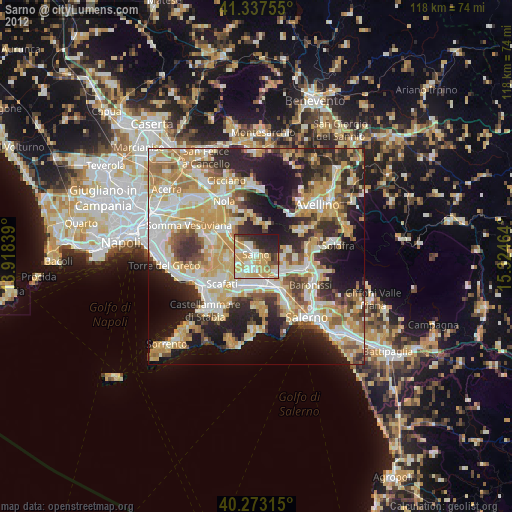
Analysis of Sarno night lights 2016
Square area 10x10 km:
 10.88%
90-99
16.5%80-89
9.69%70-79
13.27%60-69
12.24%50-59
4.25%40-49
3.91%30-39
10.54%20-29
15.14%10-19
3.57%0-9
0%Square area 50x50 km:
7.92%90-99
10.42%80-89
5.83%70-79
6.71%60-69
8.37%50-59
7.71%40-49
5.88%30-39
8.05%20-29
13.33%10-19
14.51%0-9
11.28%Clear (daylight) street map image can be seen on geolist.org.
Map coordinates:
41° 20' 15.2" North, 13° 55' 6.2" East
40° 48' 26.9" North, 14° 37' 17.4" East
40° 16' 23.3" North, 15° 19' 28.7" East
Some cities around Sarno sort by population:
• Nocera Inferiore
7.2 km =4.5 mi,  163°
163°
• Poggiomarino
6.8 km =4.2 mi,  264°
264°
• Siano
6.1 km =3.8 mi,  95°
95°
• San Marzano sul Sarno
4.8 km =3 mi,  226°
226°
• San Valentino Torio
2.4 km =1.5 mi,  220°
220°
• Striano
4 km =2.5 mi,  282°
282°
• Castel San Giorgio
7.3 km =4.5 mi,  112°
112°
• Lanzara
5.9 km =3.7 mi,  128°
128°
3167116 (p: 28,837)
Sources (retrieved 2019-11-25):
» Earth at Night: Flat Maps 2012, 2016