San Paolo di Civitate night lights from space
Night Light of San Paolo di Civitate (Apulia) from space (Italy) Src. Average luminocity for 10x10km area is 8.9529% and for 50x50km: 5.2733%.
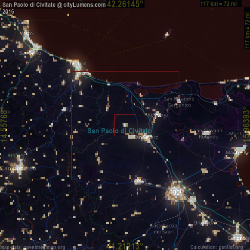
Analysis of San Paolo di Civitate night lights 2016
Square area 10x10 km:
 1.3%
1.3%90-99
1.62%80-89
0%70-79
0.32%60-69
2.92%50-59
0.16%40-49
1.14%30-39
1.3%20-29
0.65%10-19
5.52%0-9
85.06%Square area 50x50 km:
0.61%90-99
0.94%80-89
0.51%70-79
0.44%60-69
0.61%50-59
0.72%40-49
0.59%30-39
0.64%20-29
1.2%10-19
3.34%0-9
90.41%Clear (daylight) street map image can be seen on geolist.org.
Map coordinates:
42° 15' 41.2" North, 14° 33' 27.6" East
41° 44' 20.1" North, 15° 15' 38.9" East
41° 12' 43.7" North, 15° 57' 50.1" East
Some cities around San Paolo di Civitate sort by population:
• San Severo
11.6 km =7.2 mi,  120°
120°
• Lucera
26.8 km =16.7 mi,  165°
165°
• Torremaggiore
6.2 km =3.9 mi,  153°
153°
• Sannicandro Garganico
27.6 km =17.1 mi,  66°
66°
• San Marco in Lamis
31.5 km =19.6 mi,  95°
95°
• Apricena
16.1 km =10 mi, 70°
• Lesina
15.6 km =9.7 mi,  29°
29°
• Larino
29.3 km =18.2 mi,  284°
284°
3167888 (p: 5,898)
Sources (retrieved 2019-11-25):
» Earth at Night: Flat Maps 2012, 2016