Larino night lights from space
Night Light of Larino (Molise) from space (Italy) Src. Average luminocity for 10x10km area is 5.097% and for 50x50km: 6.2591%.
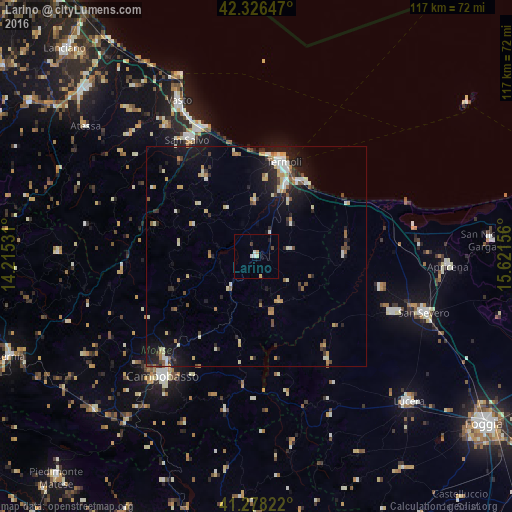
Analysis of Larino night lights 2016
Square area 10x10 km:
 0.61%
0.61%90-99
1.21%80-89
0.61%70-79
1.21%60-69
0%50-59
0%40-49
0.61%30-39
0.61%20-29
0%10-19
0.61%0-9
94.55%Square area 50x50 km:
0.57%90-99
1.21%80-89
0.8%70-79
0.75%60-69
0.75%50-59
0.58%40-49
0.63%30-39
0.65%20-29
1.53%10-19
4.43%0-9
88.09%Clear (daylight) street map image can be seen on geolist.org.
Map coordinates:
42° 19' 35.3" North, 14° 12' 55.1" East
41° 48' 16.2" North, 14° 55' 6.3" East
41° 16' 41.6" North, 15° 37' 17.6" East
Some cities around Larino sort by population:
• Campobasso
34.3 km =21.3 mi,  217°
217°
• Termoli
22.6 km =14 mi,  16°
16°
• Vasto
38.4 km =23.9 mi,  332°
332°
• San Salvo
30.7 km =19.1 mi, 330°
• Torremaggiore
33.7 km =20.9 mi,  112°
112°
• Lesina
36.6 km =22.7 mi,  80°
80°
• San Paolo di Civitate
29.3 km =18.2 mi,  104°
104°
• Montenero di Bisaccia
21.1 km =13.1 mi, 327°
3175105 (p: 5,164)
Sources (retrieved 2019-11-25):
» Earth at Night: Flat Maps 2012, 2016