San Marco in Lamis night lights from space
Night Light of San Marco in Lamis (Apulia) from space (Italy) Src. Average luminocity for 10x10km area is 6.4838% and for 50x50km: 5.8895%.
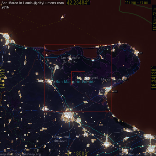
Analysis of San Marco in Lamis night lights 2016
Square area 10x10 km:
 0%
0%90-99
0.16%80-89
2.27%70-79
1.79%60-69
0.32%50-59
0.97%40-49
0.32%30-39
0.65%20-29
0%10-19
0.65%0-9
92.86%Square area 50x50 km:
0.7%90-99
1.14%80-89
0.55%70-79
0.59%60-69
0.58%50-59
0.68%40-49
0.59%30-39
0.71%20-29
1.09%10-19
4.4%0-9
88.98%Clear (daylight) street map image can be seen on geolist.org.
Map coordinates:
42° 14' 5.4" North, 14° 56' 6.5" East
41° 42' 43.6" North, 15° 38' 17.7" East
41° 11' 6.3" North, 16° 20' 29" East
Some cities around San Marco in Lamis sort by population:
• San Severo
21.5 km =13.4 mi,  262°
262°
• Manfredonia
25 km =15.5 mi,  111°
111°
• San Giovanni Rotondo
7.5 km =4.7 mi,  94°
94°
• Torremaggiore
28.7 km =17.8 mi, 264°
• Sannicandro Garganico
15.3 km =9.5 mi,  336°
336°
• Apricena
18.1 km =11.2 mi,  297°
297°
• Monte Sant'Angelo
26.8 km =16.7 mi, 91°
• Cagnano Varano
17 km =10.6 mi,  40°
40°
3168075 (p: 13,388)
Sources (retrieved 2019-11-25):
» Earth at Night: Flat Maps 2012, 2016