Cadorago-Caslino al Piano night lights from space
Night Light of Cadorago-Caslino al Piano (Lombardy) from space (Italy) Src. Average luminocity for 10x10km area is 81.1955% and for 50x50km: 63.9067%.
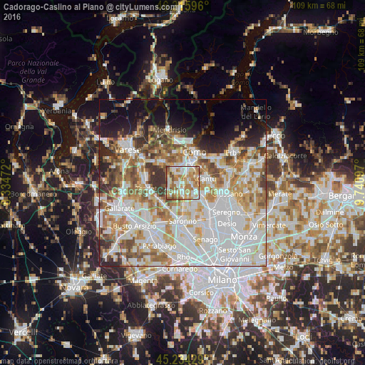
Analysis of Cadorago-Caslino al Piano night lights 2016
Square area 10x10 km:
 18.18%
90-99
23.48%80-89
11.82%70-79
17.88%60-69
18.18%50-59
6.82%40-49
3.48%30-39
0.15%20-29
0%10-19
0%0-9
0%Square area 50x50 km:
21.87%90-99
15.96%80-89
6.47%70-79
7.74%60-69
8.32%50-59
6.04%40-49
5.19%30-39
4.89%20-29
5.16%10-19
7.43%0-9
10.92%Clear (daylight) street map image can be seen on geolist.org.
Map coordinates:
46° 12' 57.5" North, 8° 20' 5" East
45° 43' 38.2" North, 9° 2' 16.2" East
45° 14' 3.4" North, 9° 44' 27.5" East
Some cities around Cadorago-Caslino al Piano sort by population:
• Lurate Caccivio
5.3 km =3.3 mi,  325°
325°
• Cermenate
4.5 km =2.8 mi,  128°
128°
• Fino Mornasco
2 km =1.2 mi,  28°
28°
• Lomazzo
3.4 km =2.1 mi,  184°
184°
• Appiano Gentile
4.5 km =2.8 mi,  281°
281°
• Guanzate
1.4 km =0.9 mi,  271°
271°
• Bregnano
3.7 km =2.3 mi,  153°
153°
• San Michele-San Giorgio
3.8 km =2.4 mi,  155°
155°
6534413 (p: 6,112)
Sources (retrieved 2019-11-25):
» Earth at Night: Flat Maps 2012, 2016