San Giovanni in Fiore night lights from space
Night Light of San Giovanni in Fiore (Calabria) from space (Italy) Src. Average luminocity for 10x10km area is 10.8231% and for 50x50km: 3.9484%.
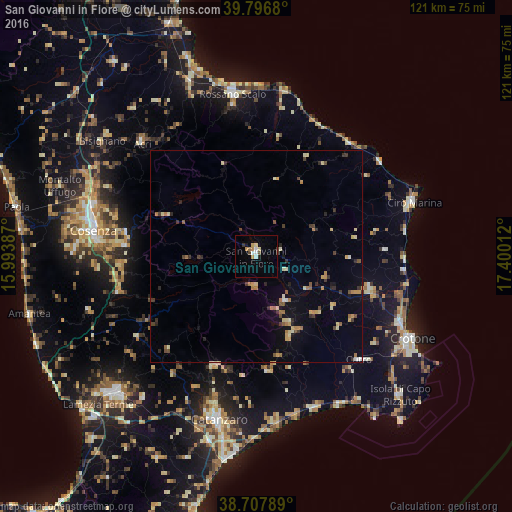
Analysis of San Giovanni in Fiore night lights 2016
Square area 10x10 km:
 1.53%
1.53%90-99
1.53%80-89
1.53%70-79
2.04%60-69
0.85%50-59
0.68%40-49
0.68%30-39
1.36%20-29
0%10-19
1.53%0-9
88.27%Square area 50x50 km:
0.13%90-99
0.45%80-89
0.59%70-79
0.67%60-69
0.61%50-59
0.38%40-49
0.46%30-39
0.64%20-29
0.71%10-19
1.09%0-9
94.28%Clear (daylight) street map image can be seen on geolist.org.
Map coordinates:
39° 47' 48.5" North, 15° 59' 37.9" East
39° 15' 16.1" North, 16° 41' 49.2" East
38° 42' 28.4" North, 17° 24' 0.4" East
Some cities around San Giovanni in Fiore sort by population:
• Cosenza
38.5 km =23.9 mi,  277°
277°
• Acri
37.9 km =23.5 mi,  315°
315°
• Cariati
34.8 km =21.6 mi,  39°
39°
• Cutro
34.9 km =21.7 mi,  134°
134°
• Mesoraca
21 km =13 mi,  158°
158°
• Petilia Policastro
17.3 km =10.7 mi, 155°
• Rossano
36.2 km =22.5 mi,  351°
351°
• Cotronei
12.6 km =7.8 mi,  146°
146°
2523461 (p: 17,358)
Sources (retrieved 2019-11-25):
» Earth at Night: Flat Maps 2012, 2016