Acri night lights from space
Night Light of Acri (Calabria) from space (Italy) Src. Average luminocity for 10x10km area is 11.0162% and for 50x50km: 14.6415%.
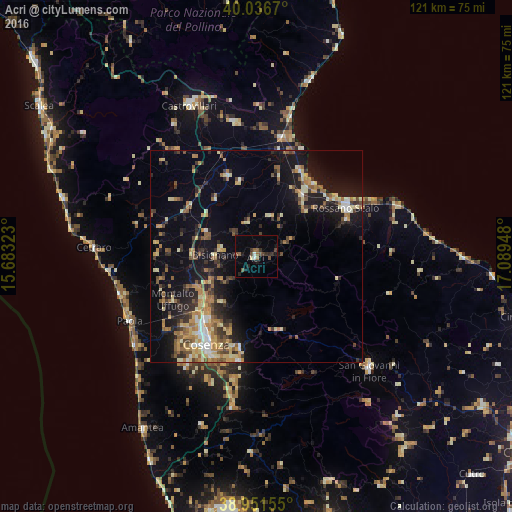
Analysis of Acri night lights 2016
Square area 10x10 km:
 0.32%
0.32%90-99
0.97%80-89
0.65%70-79
0.16%60-69
1.14%50-59
2.76%40-49
3.08%30-39
2.6%20-29
3.25%10-19
3.57%0-9
81.49%Square area 50x50 km:
0.86%90-99
1.79%80-89
2.3%70-79
2.08%60-69
2.35%50-59
2.68%40-49
1.54%30-39
2.44%20-29
3.63%10-19
10.82%0-9
69.5%Clear (daylight) street map image can be seen on geolist.org.
Map coordinates:
40° 2' 12.1" North, 15° 40' 59.6" East
39° 29' 46.5" North, 16° 23' 10.9" East
38° 57' 5.6" North, 17° 5' 22.1" East
Some cities around Acri sort by population:
• Quattromiglia
21.1 km =13.1 mi,  217°
217°
• Corigliano Scalo
18.2 km =11.3 mi,  36°
36°
• Marina di Schiavonea
21.2 km =13.2 mi, 36°
• Spezzano Albanese
20.3 km =12.6 mi,  341°
341°
• Roggiano Gravina
23.5 km =14.6 mi,  305°
305°
• Corigliano Calabro
15.9 km =9.9 mi,  45°
45°
• Rossano
23.1 km =14.4 mi,  67°
67°
• Bisignano
9.1 km =5.7 mi,  277°
277°
2525772 (p: 9,862)
Sources (retrieved 2019-11-25):
» Earth at Night: Flat Maps 2012, 2016