Petilia Policastro night lights from space
Night Light of Petilia Policastro (Calabria) from space (Italy) Src. Average luminocity for 10x10km area is 19.8263% and for 50x50km: 10.2944%.
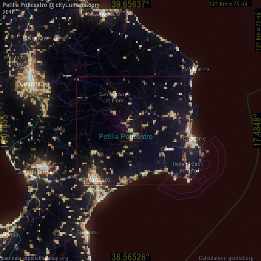
Analysis of Petilia Policastro night lights 2016
Square area 10x10 km:
 0.32%
0.32%90-99
1.79%80-89
4.06%70-79
3.08%60-69
5.03%50-59
2.6%40-49
1.3%30-39
1.62%20-29
1.79%10-19
18.83%0-9
59.58%Square area 50x50 km:
0.52%90-99
1.2%80-89
1.54%70-79
1.59%60-69
1.44%50-59
1.32%40-49
0.84%30-39
1.55%20-29
2.13%10-19
7.42%0-9
80.44%Clear (daylight) street map image can be seen on geolist.org.
Map coordinates:
39° 39' 22.9" North, 16° 4' 42.8" East
39° 6' 46.5" North, 16° 46' 54" East
38° 33' 54.9" North, 17° 29' 5.3" East
Some cities around Petilia Policastro sort by population:
• Catanzaro
30 km =18.6 mi,  211°
211°
• Crotone
30.1 km =18.7 mi,  96°
96°
• San Giovanni in Fiore
17.3 km =10.7 mi,  335°
335°
• Cirò Marina
41 km =25.5 mi,  46°
46°
• Isola di Capo Rizzuto
31.9 km =19.8 mi,  122°
122°
• Cutro
19.7 km =12.2 mi, 116°
• Mesoraca
3.8 km =2.4 mi,  171°
171°
• Cotronei
5.2 km =3.2 mi,  355°
355°
2523825 (p: 5,704)
Sources (retrieved 2019-11-25):
» Earth at Night: Flat Maps 2012, 2016