Mesoraca night lights from space
Night Light of Mesoraca (Calabria) from space (Italy) Src. Average luminocity for 10x10km area is 16.0812% and for 50x50km: 11.6451%.
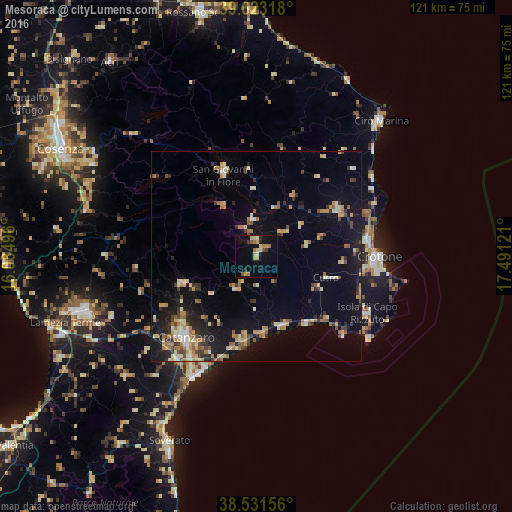
Analysis of Mesoraca night lights 2016
Square area 10x10 km:
 0%
0%90-99
1.3%80-89
3.57%70-79
3.73%60-69
3.08%50-59
1.14%40-49
1.14%30-39
1.62%20-29
1.14%10-19
10.88%0-9
72.4%Square area 50x50 km:
0.62%90-99
1.39%80-89
1.77%70-79
1.83%60-69
1.82%50-59
1.38%40-49
1.04%30-39
1.67%20-29
2.54%10-19
8.6%0-9
77.34%Clear (daylight) street map image can be seen on geolist.org.
Map coordinates:
39° 37' 23.4" North, 16° 5' 5.9" East
39° 4' 46.1" North, 16° 47' 17.1" East
38° 31' 53.6" North, 17° 29' 28.4" East
Some cities around Mesoraca sort by population:
• Catanzaro
27.2 km =16.9 mi,  216°
216°
• Crotone
29.3 km =18.2 mi,  89°
89°
• San Giovanni in Fiore
21 km =13 mi,  338°
338°
• Isola di Capo Rizzuto
29.5 km =18.3 mi,  117°
117°
• Cutro
17.8 km =11.1 mi,  106°
106°
• Girifalco
42.1 km =26.2 mi,  227°
227°
• Petilia Policastro
3.8 km =2.4 mi,  351°
351°
• Cotronei
8.9 km =5.5 mi, 353°
2524172 (p: 6,158)
Sources (retrieved 2019-11-25):
» Earth at Night: Flat Maps 2012, 2016