Montebello Vicentino night lights from space
Night Light of Montebello Vicentino (Veneto) from space (Italy) Src. Average luminocity for 10x10km area is 54.5524% and for 50x50km: 33.3804%.
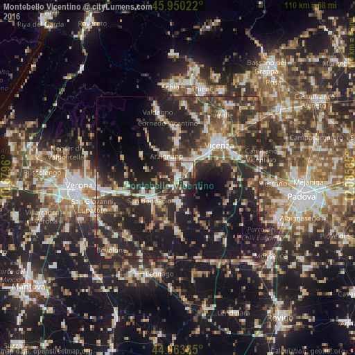
Analysis of Montebello Vicentino night lights 2016
Square area 10x10 km:
 8.57%
8.57%90-99
14.6%80-89
3.49%70-79
5.24%60-69
6.03%50-59
7.62%40-49
12.86%30-39
13.65%20-29
23.97%10-19
3.97%0-9
0%Square area 50x50 km:
3.61%90-99
5.27%80-89
3.21%70-79
3.51%60-69
3.79%50-59
5.28%40-49
6.8%30-39
8.25%20-29
16.84%10-19
24.83%0-9
18.62%Clear (daylight) street map image can be seen on geolist.org.
Map coordinates:
45° 57' 0.8" North, 10° 40' 46.6" East
45° 27' 33.1" North, 11° 22' 57.8" East
44° 57' 49.9" North, 12° 5' 9.1" East
Some cities around Montebello Vicentino sort by population:
• Arzignano
7.8 km =4.8 mi,  331°
331°
• San Bonifacio
11 km =6.8 mi,  230°
230°
• Lonigo
8.2 km =5.1 mi,  179°
179°
• Chiampo
12.5 km =7.8 mi,  321°
321°
• Altavilla Vicentina
9 km =5.6 mi,  48°
48°
• Creazzo
10.9 km =6.8 mi,  42°
42°
• Trissino
11.2 km =7 mi,  357°
357°
• Soave
11.5 km =7.1 mi,  247°
247°
3173030 (p: 5,097)
Sources (retrieved 2019-11-25):
» Earth at Night: Flat Maps 2012, 2016