Pontremoli night lights from space
Night Light of Pontremoli (Tuscany) from space (Italy) Src. Average luminocity for 10x10km area is 5.7175% and for 50x50km: 2.7227%.
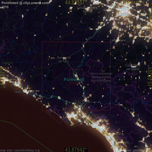
Analysis of Pontremoli night lights 2016
Square area 10x10 km:
 0.48%
0.48%90-99
0.16%80-89
0%70-79
0%60-69
0.63%50-59
2.54%40-49
3.17%30-39
1.43%20-29
1.75%10-19
0%0-9
89.84%Square area 50x50 km:
0.12%90-99
0.2%80-89
0.26%70-79
0.25%60-69
0.44%50-59
0.6%40-49
0.58%30-39
0.67%20-29
0.86%10-19
1.69%0-9
94.33%Clear (daylight) street map image can be seen on geolist.org.
Map coordinates:
44° 52' 32.1" North, 9° 10' 32.7" East
44° 22' 30.5" North, 9° 52' 44" East
43° 52' 13.5" North, 10° 34' 55.2" East
Some cities around Pontremoli sort by population:
• La Spezia
30.6 km =19 mi,  188°
188°
• Sarzana
30 km =18.6 mi,  167°
167°
• Lerici
33.4 km =20.8 mi,  175°
175°
• Santo Stefano di Magra
25.4 km =15.8 mi, 172°
• Colombiera-Molicciara
33.7 km =20.9 mi,  161°
161°
• Ceparana-Carpena
23.2 km =14.4 mi, 179°
• Arcola
28.7 km =17.8 mi, 174°
• Borgo Val di Taro
15.4 km =9.6 mi,  325°
325°
3170191 (p: 5,208)
Sources (retrieved 2019-11-25):
» Earth at Night: Flat Maps 2012, 2016