Borgo Val di Taro night lights from space
Night Light of Borgo Val di Taro (Emilia-Romagna) from space (Italy) Src. Average luminocity for 10x10km area is 2.0635% and for 50x50km: 1.2314%.
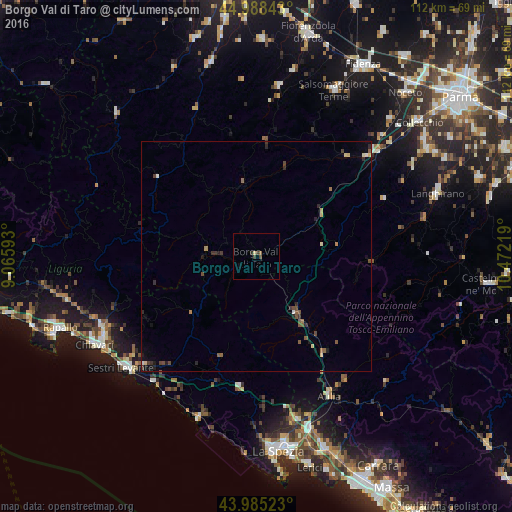
Analysis of Borgo Val di Taro night lights 2016
Square area 10x10 km:
 0%
0%90-99
0%80-89
0.63%70-79
0%60-69
0%50-59
0.63%40-49
1.11%30-39
0.79%20-29
0.63%10-19
0.16%0-9
96.03%Square area 50x50 km:
0.05%90-99
0.07%80-89
0.18%70-79
0.06%60-69
0.2%50-59
0.29%40-49
0.36%30-39
0.29%20-29
0.33%10-19
0.34%0-9
97.83%Clear (daylight) street map image can be seen on geolist.org.
Map coordinates:
44° 59' 18.3" North, 9° 3' 57.3" East
44° 29' 20.4" North, 9° 46' 8.6" East
43° 59' 6.8" North, 10° 28' 19.9" East
Some cities around Borgo Val di Taro sort by population:
• Chiavari
40.3 km =25 mi,  241°
241°
• Sestri Levante
38.1 km =23.7 mi,  230°
230°
• Salsomaggiore Terme
40.2 km =25 mi,  25°
25°
• Lavagna
38.7 km =24 mi, 238°
• Santo Stefano di Magra
39.7 km =24.7 mi,  162°
162°
• Ceparana-Carpena
37 km =23 mi,  165°
165°
• Casarza Ligure
35.2 km =21.9 mi, 226°
• Pontremoli
15.4 km =9.6 mi,  145°
145°
3181746 (p: 5,466)
Sources (retrieved 2019-11-25):
» Earth at Night: Flat Maps 2012, 2016