Pollena Trocchia night lights from space
Night Light of Pollena Trocchia (Campania) from space (Italy) Src. Average luminocity for 10x10km area is 78.9677% and for 50x50km: 52.8415%.
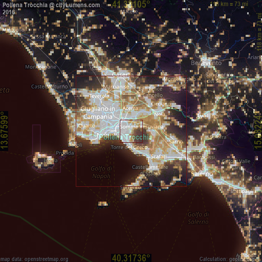
Analysis of Pollena Trocchia night lights 2016
Square area 10x10 km:
 30.78%
90-99
22.45%80-89
7.99%70-79
7.31%60-69
5.95%50-59
5.1%40-49
5.1%30-39
13.78%20-29
1.53%10-19
0%0-9
0%Square area 50x50 km:
13.89%90-99
13.17%80-89
5.44%70-79
7.29%60-69
7.89%50-59
5.39%40-49
4.18%30-39
6.44%20-29
9.95%10-19
9.71%0-9
16.65%Clear (daylight) street map image can be seen on geolist.org.
Map coordinates:
41° 22' 51.8" North, 13° 40' 33.6" East
40° 51' 4.8" North, 14° 22' 44.8" East
40° 19' 2.5" North, 15° 4' 56.1" East
Some cities around Pollena Trocchia sort by population:
• Ponticelli
4.1 km =2.5 mi,  274°
274°
• San Giorgio a Cremano
3.8 km =2.4 mi,  236°
236°
• Barra
5.2 km =3.2 mi,  259°
259°
• Volla
4.1 km =2.5 mi,  307°
307°
• Sant'Anastasia
2.7 km =1.7 mi,  45°
45°
• Cercola
2.1 km =1.3 mi,  298°
298°
• San Sebastiano al Vesuvio
1.5 km =0.9 mi,  234°
234°
• Massa di Somma
0.7 km =0.4 mi,  207°
207°
6534255 (p: 11,880)
Sources (retrieved 2019-11-25):
» Earth at Night: Flat Maps 2012, 2016