Pasian di Prato night lights from space
Night Light of Pasian di Prato (Friuli Venezia Giulia) from space (Italy) Src. Average luminocity for 10x10km area is 55.3608% and for 50x50km: 20.0883%.
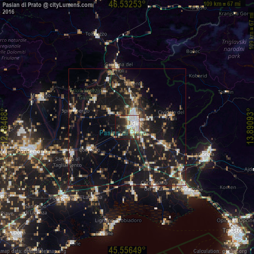
Analysis of Pasian di Prato night lights 2016
Square area 10x10 km:
 13.92%
90-99
17.9%80-89
5.54%70-79
4.97%60-69
3.55%50-59
4.55%40-49
3.98%30-39
5.26%20-29
18.61%10-19
19.32%0-9
2.41%Square area 50x50 km:
1.66%90-99
3.38%80-89
1.63%70-79
1.59%60-69
2.29%50-59
3.17%40-49
3.35%30-39
3.78%20-29
6.58%10-19
25.14%0-9
47.44%Clear (daylight) street map image can be seen on geolist.org.
Map coordinates:
46° 31' 57.1" North, 12° 29' 4.8" East
46° 2' 48" North, 13° 11' 16.1" East
45° 33' 23.4" North, 13° 53' 27.3" East
Some cities around Pasian di Prato sort by population:
• Udine
4.6 km =2.9 mi,  56°
56°
• Codroipo
18.5 km =11.5 mi,  240°
240°
• Tavagnacco
7.5 km =4.7 mi,  20°
20°
• Tarcento
18.6 km =11.6 mi,  6°
6°
• Majano
18.4 km =11.4 mi,  328°
328°
• Tricesimo
12.8 km =8 mi, 9°
• Manzano
16 km =9.9 mi,  113°
113°
• Martignacco
6.4 km =4 mi,  324°
324°
3171432 (p: 5,447)
Sources (retrieved 2019-11-25):
» Earth at Night: Flat Maps 2012, 2016