Tricesimo night lights from space
Night Light of Tricesimo (Friuli Venezia Giulia) from space (Italy) Src. Average luminocity for 10x10km area is 35.0696% and for 50x50km: 14.906%.
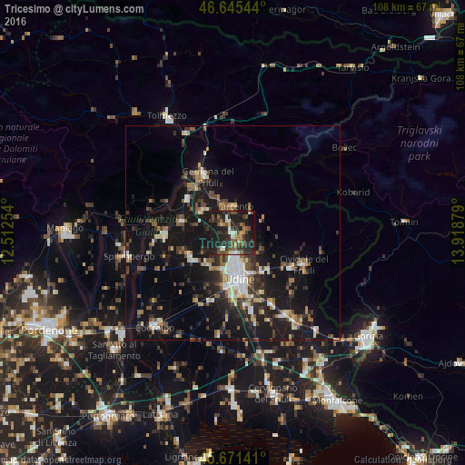
Analysis of Tricesimo night lights 2016
Square area 10x10 km:
 0.71%
0.71%90-99
6.53%80-89
2.84%70-79
2.56%60-69
3.98%50-59
7.24%40-49
7.95%30-39
11.51%20-29
20.17%10-19
33.66%0-9
2.84%Square area 50x50 km:
1.29%90-99
2.62%80-89
1.19%70-79
1.15%60-69
1.8%50-59
2.4%40-49
2.36%30-39
2.85%20-29
4.65%10-19
17.56%0-9
62.11%Clear (daylight) street map image can be seen on geolist.org.
Map coordinates:
46° 38' 43.6" North, 12° 30' 45.1" East
46° 9' 38.1" North, 13° 12' 56.4" East
45° 40' 17.1" North, 13° 55' 7.6" East
Some cities around Tricesimo sort by population:
• Udine
10.3 km =6.4 mi,  170°
170°
• Tavagnacco
5.7 km =3.5 mi, 174°
• Gemona
14.5 km =9 mi,  330°
330°
• Tarcento
5.8 km =3.6 mi,  359°
359°
• Buia
9.5 km =5.9 mi,  307°
307°
• Majano
12.2 km =7.6 mi,  284°
284°
• Pasian di Prato
12.8 km =8 mi,  189°
189°
• Martignacco
9.5 km =5.9 mi,  217°
217°
3165189 (p: 5,590)
Sources (retrieved 2019-11-25):
» Earth at Night: Flat Maps 2012, 2016