Tavagnacco night lights from space
Night Light of Tavagnacco (Friuli Venezia Giulia) from space (Italy) Src. Average luminocity for 10x10km area is 53.5% and for 50x50km: 16.4749%.
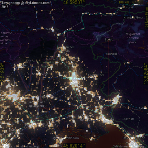
Analysis of Tavagnacco night lights 2016
Square area 10x10 km:
 10.37%
90-99
14.35%80-89
4.97%70-79
2.7%60-69
4.83%50-59
10.51%40-49
7.81%30-39
9.8%20-29
23.86%10-19
10.51%0-9
0.28%Square area 50x50 km:
1.34%90-99
2.75%80-89
1.32%70-79
1.31%60-69
1.99%50-59
2.71%40-49
2.55%30-39
3.04%20-29
5.22%10-19
20.77%0-9
56.98%Clear (daylight) street map image can be seen on geolist.org.
Map coordinates:
46° 35' 42.3" North, 12° 31' 9.8" East
46° 6' 35.1" North, 13° 13' 21" East
45° 37' 12.5" North, 13° 55' 32.3" East
Some cities around Tavagnacco sort by population:
• Udine
4.6 km =2.9 mi,  165°
165°
• Cividale del Friuli
16 km =9.9 mi,  97°
97°
• Tarcento
11.4 km =7.1 mi,  357°
357°
• Buia
14 km =8.7 mi,  324°
324°
• Majano
15.1 km =9.4 mi,  304°
304°
• Tricesimo
5.7 km =3.5 mi,  354°
354°
• Pasian di Prato
7.5 km =4.7 mi,  200°
200°
• Martignacco
6.6 km =4.1 mi,  253°
253°
3165896 (p: 11,638)
Sources (retrieved 2019-11-25):
» Earth at Night: Flat Maps 2012, 2016