Manzano night lights from space
Night Light of Manzano (Friuli Venezia Giulia) from space (Italy) Src. Average luminocity for 10x10km area is 29.7457% and for 50x50km: 20.5094%.
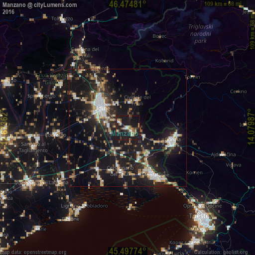
Analysis of Manzano night lights 2016
Square area 10x10 km:
 1.56%
1.56%90-99
5.26%80-89
3.27%70-79
2.41%60-69
5.82%50-59
2.84%40-49
3.84%30-39
2.98%20-29
6.53%10-19
60.23%0-9
5.26%Square area 50x50 km:
2.17%90-99
3.8%80-89
1.76%70-79
1.86%60-69
2.07%50-59
2.98%40-49
2.99%30-39
3.22%20-29
7.09%10-19
25.33%0-9
46.73%Clear (daylight) street map image can be seen on geolist.org.
Map coordinates:
46° 28' 29.3" North, 12° 40' 25" East
45° 59' 18.3" North, 13° 22' 36.3" East
45° 29' 51.9" North, 14° 4' 47.5" East
Some cities around Manzano sort by population:
• Udine
14 km =8.7 mi,  309°
309°
• Cervignano del Friuli
18.9 km =11.7 mi,  188°
188°
• Tavagnacco
18 km =11.2 mi,  318°
318°
• Cividale del Friuli
12 km =7.5 mi,  19°
19°
• Gradisca d'Isonzo
14.4 km =8.9 mi,  137°
137°
• Cormons
7.9 km =4.9 mi,  117°
117°
• Pasian di Prato
16 km =9.9 mi,  293°
293°
• Dobrovo, SI
11.6 km =7.2 mi,  85°
85°
3174045 (p: 5,168)
Sources (retrieved 2019-11-25):
» Earth at Night: Flat Maps 2012, 2016