Oderzo night lights from space
Night Light of Oderzo (Veneto) from space (Italy) Src. Average luminocity for 10x10km area is 38.3508% and for 50x50km: 37.6886%.
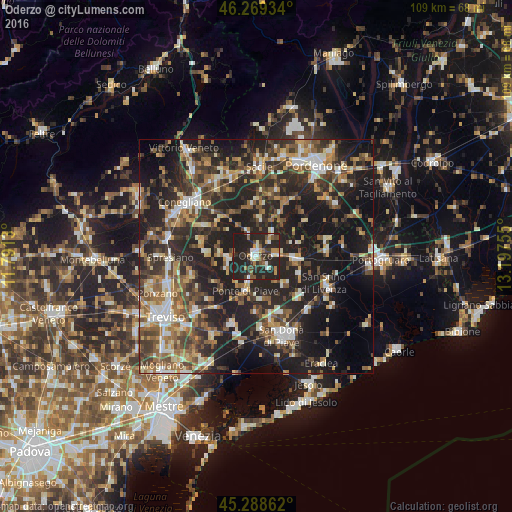
Analysis of Oderzo night lights 2016
Square area 10x10 km:
 4.29%
4.29%90-99
5.24%80-89
3.17%70-79
4.6%60-69
3.33%50-59
5.24%40-49
7.3%30-39
6.83%20-29
39.21%10-19
20.79%0-9
0%Square area 50x50 km:
3.72%90-99
6.18%80-89
3.69%70-79
4.45%60-69
5.89%50-59
6.61%40-49
7.4%30-39
7.56%20-29
16.86%10-19
25.96%0-9
11.69%Clear (daylight) street map image can be seen on geolist.org.
Map coordinates:
46° 16' 9.6" North, 11° 47' 28.7" East
45° 46' 52.1" North, 12° 29' 39.9" East
45° 17' 19" North, 13° 11' 51.2" East
Some cities around Oderzo sort by population:
• San Vendemiano
16.2 km =10.1 mi,  316°
316°
• Mareno di Piave
14.2 km =8.8 mi,  300°
300°
• Motta di Livenza
8.5 km =5.3 mi,  94°
94°
• Brugnera
13.7 km =8.5 mi,  15°
15°
• Salgareda
8.5 km =5.3 mi,  183°
183°
• Ceggia
15.5 km =9.6 mi,  132°
132°
• Vazzola
9 km =5.6 mi,  312°
312°
• Noventa di Piave
13.8 km =8.6 mi,  167°
167°
3172116 (p: 15,764)
Sources (retrieved 2019-11-25):
» Earth at Night: Flat Maps 2012, 2016