San Vendemiano night lights from space
Night Light of San Vendemiano (Veneto) from space (Italy) Src. Average luminocity for 10x10km area is 54.1161% and for 50x50km: 31.9335%.
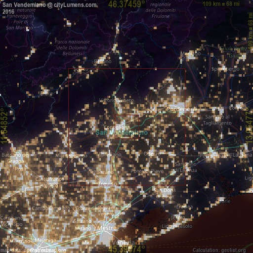
Analysis of San Vendemiano night lights 2016
Square area 10x10 km:
 6.85%
6.85%90-99
11.31%80-89
5.65%70-79
6.55%60-69
7.44%50-59
6.25%40-49
18.15%30-39
15.63%20-29
18.9%10-19
3.27%0-9
0%Square area 50x50 km:
2.8%90-99
5%80-89
2.98%70-79
3.55%60-69
4.85%50-59
5.39%40-49
6.22%30-39
6.65%20-29
17.53%10-19
22.15%0-9
22.9%Clear (daylight) street map image can be seen on geolist.org.
Map coordinates:
46° 22' 28.5" North, 11° 38' 54.7" East
45° 53' 14.4" North, 12° 21' 5.9" East
45° 23' 44.7" North, 13° 3' 17.2" East
Some cities around San Vendemiano sort by population:
• Conegliano
3.8 km =2.4 mi,  271°
271°
• Vittorio Veneto
11.1 km =6.9 mi,  339°
339°
• Sacile
13.8 km =8.6 mi,  57°
57°
• Santa Lucia di Piave
5.3 km =3.3 mi,  237°
237°
• Mareno di Piave
4.8 km =3 mi,  193°
193°
• Priula-Colfosco
10.4 km =6.5 mi,  223°
223°
• Caneva
12.1 km =7.5 mi,  40°
40°
• Vazzola
7.3 km =4.5 mi,  142°
142°
3167213 (p: 8,776)
Sources (retrieved 2019-11-25):
» Earth at Night: Flat Maps 2012, 2016