Montecchio Emilia night lights from space
Night Light of Montecchio Emilia (Emilia-Romagna) from space (Italy) Src. Average luminocity for 10x10km area is 42.0333% and for 50x50km: 31.628%.
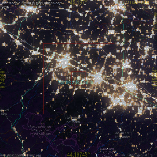
Analysis of Montecchio Emilia night lights 2016
Square area 10x10 km:
 4.24%
4.24%90-99
8.18%80-89
3.64%70-79
3.33%60-69
4.55%50-59
3.48%40-49
5.61%30-39
13.33%20-29
46.82%10-19
6.82%0-9
0%Square area 50x50 km:
4.84%90-99
6.3%80-89
2.92%70-79
2.87%60-69
3.2%50-59
3.76%40-49
4.63%30-39
7.13%20-29
15.34%10-19
21.96%0-9
27.04%Clear (daylight) street map image can be seen on geolist.org.
Map coordinates:
45° 11' 49.2" North, 9° 44' 56.4" East
44° 41' 57.7" North, 10° 27' 7.6" East
44° 11' 50.7" North, 11° 9' 18.9" East
Some cities around Montecchio Emilia sort by population:
• Parma
14.9 km =9.3 mi,  318°
318°
• Reggio nell'Emilia
14.2 km =8.8 mi,  90°
90°
• Cavriago
5.9 km =3.7 mi,  95°
95°
• Sant'Ilario d'Enza
6.6 km =4.1 mi,  356°
356°
• Castelnovo di Sotto
15.5 km =9.6 mi,  35°
35°
• Cadelbosco di Sopra
13.7 km =8.5 mi,  57°
57°
• Bibbiano
4.4 km =2.7 mi,  156°
156°
• Traversetolo
8.5 km =5.3 mi,  221°
221°
3172980 (p: 8,482)
Sources (retrieved 2019-11-25):
» Earth at Night: Flat Maps 2012, 2016