Cadelbosco di Sopra night lights from space
Night Light of Cadelbosco di Sopra (Emilia-Romagna) from space (Italy) Src. Average luminocity for 10x10km area is 46.8545% and for 50x50km: 40.1453%.
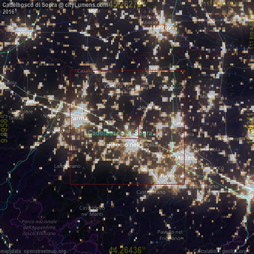
Analysis of Cadelbosco di Sopra night lights 2016
Square area 10x10 km:
 8.33%
8.33%90-99
10.45%80-89
1.67%70-79
6.67%60-69
3.64%50-59
7.42%40-49
7.88%30-39
9.85%20-29
22.27%10-19
21.82%0-9
0%Square area 50x50 km:
6.79%90-99
8.47%80-89
3.39%70-79
3.51%60-69
4.31%50-59
5.41%40-49
6.34%30-39
8.27%20-29
16.85%10-19
26.24%0-9
10.43%Clear (daylight) street map image can be seen on geolist.org.
Map coordinates:
45° 15' 46" North, 9° 53' 45.1" East
44° 45' 56.6" North, 10° 35' 56.3" East
44° 15' 51.7" North, 11° 18' 7.6" East
Some cities around Cadelbosco di Sopra sort by population:
• Reggio nell'Emilia
7.9 km =4.9 mi,  161°
161°
• Correggio
14.6 km =9.1 mi,  89°
89°
• Novellara
13.4 km =8.3 mi,  49°
49°
• Cavriago
9.8 km =6.1 mi,  216°
216°
• Montecchio Emilia
13.7 km =8.5 mi,  237°
237°
• Sant'Ilario d'Enza
12 km =7.5 mi,  266°
266°
• Bagnolo in Piano
5.9 km =3.7 mi, 91°
• Castelnovo di Sotto
5.8 km =3.6 mi,  334°
334°
3181311 (p: 6,162)
Sources (retrieved 2019-11-25):
» Earth at Night: Flat Maps 2012, 2016