Trissino night lights from space
Night Light of Trissino (Veneto) from space (Italy) Src. Average luminocity for 10x10km area is 41.9045% and for 50x50km: 33.4621%.
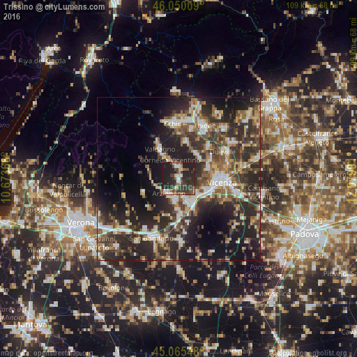
Analysis of Trissino night lights 2016
Square area 10x10 km:
 4.85%
4.85%90-99
5.91%80-89
3.79%70-79
3.79%60-69
4.24%50-59
5.15%40-49
13.03%30-39
12.27%20-29
27.88%10-19
19.09%0-9
0%Square area 50x50 km:
3.95%90-99
5.84%80-89
3.26%70-79
3.53%60-69
4.05%50-59
5.71%40-49
6.97%30-39
8.11%20-29
15.79%10-19
16.86%0-9
25.93%Clear (daylight) street map image can be seen on geolist.org.
Map coordinates:
46° 3' 0.3" North, 10° 40' 25.2" East
45° 33' 35.8" North, 11° 22' 36.4" East
45° 3' 55.7" North, 12° 4' 47.7" East
Some cities around Trissino sort by population:
• Arzignano
5.5 km =3.4 mi,  216°
216°
• Montecchio Maggiore-Alte Ceccato
6.8 km =4.2 mi,  156°
156°
• Chiampo
7.4 km =4.6 mi,  259°
259°
• Caldogno-Rettorgole-Cresole
11.2 km =7 mi,  61°
61°
• Altavilla Vicentina
8.8 km =5.5 mi,  125°
125°
• Creazzo
8.5 km =5.3 mi,  111°
111°
• Cornedo Vicentino
7.2 km =4.5 mi,  331°
331°
• Montebello Vicentino
11.2 km =7 mi,  177°
177°
3165157 (p: 6,255)
Sources (retrieved 2019-11-25):
» Earth at Night: Flat Maps 2012, 2016