Minervino Murge night lights from space
Night Light of Minervino Murge (Apulia) from space (Italy) Src. Average luminocity for 10x10km area is 6.1396% and for 50x50km: 7.7496%.
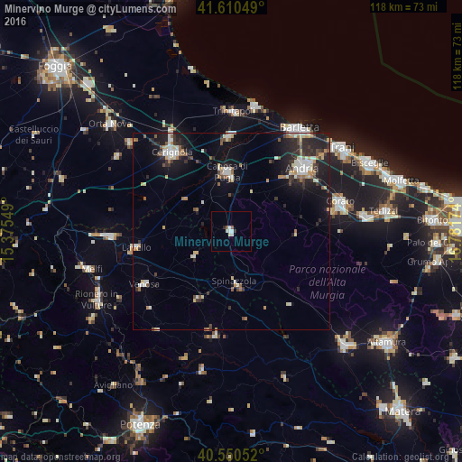
Analysis of Minervino Murge night lights 2016
Square area 10x10 km:
 0.97%
0.97%90-99
2.27%80-89
0.65%70-79
0%60-69
0%50-59
1.3%40-49
0%30-39
0.32%20-29
0.97%10-19
0%0-9
93.51%Square area 50x50 km:
0.95%90-99
1.42%80-89
0.82%70-79
0.69%60-69
0.93%50-59
0.82%40-49
0.75%30-39
1.1%20-29
2.87%10-19
5.57%0-9
84.1%Clear (daylight) street map image can be seen on geolist.org.
Map coordinates:
41° 36' 37.8" North, 15° 22' 31.8" East
41° 4' 57.5" North, 16° 4' 43" East
40° 33' 1.9" North, 16° 46' 54.3" East
Some cities around Minervino Murge sort by population:
• Andria
24.7 km =15.3 mi,  48°
48°
• Cerignola
25.4 km =15.8 mi,  322°
322°
• Canosa di Puglia
15.2 km =9.4 mi,  356°
356°
• San Ferdinando di Puglia
24.5 km =15.2 mi, 358°
• Lavello
24.6 km =15.3 mi,  260°
260°
• Venosa
26 km =16.2 mi,  239°
239°
• Spinazzola
13.2 km =8.2 mi,  175°
175°
• Genzano di Lucania
26.6 km =16.5 mi,  188°
188°
3173404 (p: 9,242)
Sources (retrieved 2019-11-25):
» Earth at Night: Flat Maps 2012, 2016