Dobrovo night lights from space
Night Light of Dobrovo (Brda) from space (Slovenia) Src. Average luminocity for 10x10km area is 4.8594% and for 50x50km: 16.1372%.
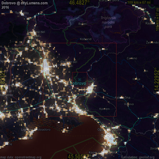
Analysis of Dobrovo night lights 2016
Square area 10x10 km:
 0.57%
0.57%90-99
0.85%80-89
0%70-79
0%60-69
0.28%50-59
0%40-49
0%30-39
0%20-29
0.28%10-19
8.52%0-9
89.49%Square area 50x50 km:
2.02%90-99
3.23%80-89
1.43%70-79
1.46%60-69
1.71%50-59
1.98%40-49
2.31%30-39
2.37%20-29
5.29%10-19
19.42%0-9
58.78%Clear (daylight) street map image can be seen on geolist.org.
Map coordinates:
46° 28' 57.7" North, 12° 49' 23.8" East
45° 59' 47" North, 13° 31' 35" East
45° 30' 20.8" North, 14° 13' 46.3" East
Some cities around Dobrovo sort by population:
• Gorizia, IT
9.6 km =6 mi,  129°
129°
• Nova Gorica
10.4 km =6.5 mi,  115°
115°
• Cividale del Friuli, IT
12.9 km =8 mi,  324°
324°
• Gradisca d'Isonzo, IT
11.7 km =7.3 mi,  189°
189°
• Cormons, IT
6.5 km =4 mi,  225°
225°
• Manzano, IT
11.6 km =7.2 mi,  265°
265°
• Šempeter pri Gorici
11.7 km =7.3 mi, 130°
• Miren
12.8 km =8 mi,  150°
150°
3201896 (p: 368)
Sources (retrieved 2019-11-25):
» Earth at Night: Flat Maps 2012, 2016