San Salvo night lights from space
Night Light of San Salvo (Abruzzo) from space (Italy) Src. Average luminocity for 10x10km area is 33.5968% and for 50x50km: 10.8162%.
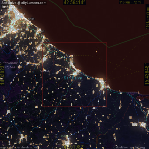
Analysis of San Salvo night lights 2016
Square area 10x10 km:
 4.29%
4.29%90-99
9.37%80-89
2.22%70-79
2.54%60-69
5.08%50-59
3.02%40-49
1.75%30-39
5.24%20-29
11.9%10-19
38.25%0-9
16.35%Square area 50x50 km:
1.02%90-99
2.11%80-89
1.18%70-79
1.19%60-69
1.11%50-59
1.27%40-49
1.08%30-39
1.5%20-29
3.48%10-19
9.07%0-9
77%Clear (daylight) street map image can be seen on geolist.org.
Map coordinates:
42° 33' 50.9" North, 14° 1' 48.8" East
42° 2' 38.9" North, 14° 44' 0.1" East
41° 31' 11.4" North, 15° 26' 11.3" East
Some cities around San Salvo sort by population:
• Campobasso
54.2 km =33.7 mi,  185°
185°
• Termoli
22.1 km =13.7 mi,  102°
102°
• Lanciano
34.9 km =21.7 mi,  305°
305°
• Vasto
7.8 km =4.8 mi,  343°
343°
• Ortona
43.6 km =27.1 mi,  321°
321°
• Montenero di Bisaccia
9.7 km =6 mi,  156°
156°
• Larino
30.7 km =19.1 mi,  150°
150°
• Casalbordino-Miracoli
16.5 km =10.3 mi, 317°
3167751 (p: 17,123)
Sources (retrieved 2019-11-25):
» Earth at Night: Flat Maps 2012, 2016