Grottaminarda night lights from space
Night Light of Grottaminarda (Campania) from space (Italy) Src. Average luminocity for 10x10km area is 34.3019% and for 50x50km: 18.5575%.
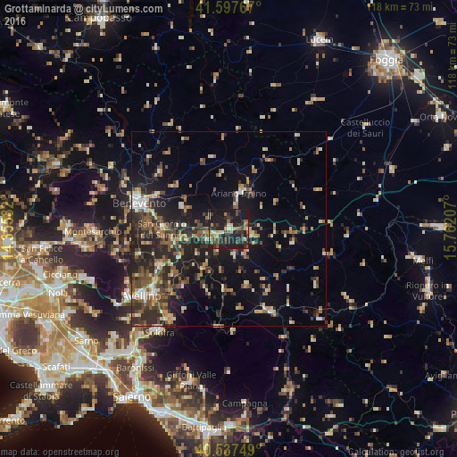
Analysis of Grottaminarda night lights 2016
Square area 10x10 km:
 1.95%
1.95%90-99
4.55%80-89
2.6%70-79
3.08%60-69
4.06%50-59
6.17%40-49
7.31%30-39
10.23%20-29
19.97%10-19
38.8%0-9
1.3%Square area 50x50 km:
1%90-99
2.48%80-89
2.12%70-79
1.95%60-69
2.57%50-59
3.58%40-49
3.02%30-39
4.31%20-29
7.68%10-19
12.75%0-9
58.55%Clear (daylight) street map image can be seen on geolist.org.
Map coordinates:
41° 35' 51.6" North, 14° 21' 21" East
41° 4' 11" North, 15° 3' 32.2" East
40° 32' 15" North, 15° 45' 43.5" East
Some cities around Grottaminarda sort by population:
• Benevento
24.5 km =15.2 mi,  286°
286°
• Avellino
28.3 km =17.6 mi,  232°
232°
• Ariano Irpino-Martiri
10.8 km =6.7 mi,  21°
21°
• Atripalda
25.7 km =16 mi, 229°
• San Giorgio del Sannio
17.2 km =10.7 mi,  269°
269°
• Montella
25.4 km =15.8 mi,  187°
187°
• Serino
28.6 km =17.8 mi,  213°
213°
• Sala
28.5 km =17.7 mi, 213°
3175772 (p: 5,355)
Sources (retrieved 2019-11-25):
» Earth at Night: Flat Maps 2012, 2016