Gardone Val Trompia night lights from space
Night Light of Gardone Val Trompia (Lombardy) from space (Italy) Src. Average luminocity for 10x10km area is 26.6455% and for 50x50km: 32.283%.
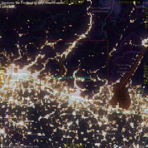
Analysis of Gardone Val Trompia night lights 2016
Square area 10x10 km:
 4.7%
4.7%90-99
4.09%80-89
2.27%70-79
2.73%60-69
2.58%50-59
2.73%40-49
3.03%30-39
0.91%20-29
10.45%10-19
35.15%0-9
31.36%Square area 50x50 km:
5.42%90-99
6.33%80-89
2.72%70-79
3.31%60-69
4.69%50-59
6.17%40-49
5.32%30-39
6.62%20-29
7.68%10-19
14.44%0-9
37.28%Clear (daylight) street map image can be seen on geolist.org.
Map coordinates:
46° 10' 49.3" North, 9° 28' 59.6" East
45° 41' 28.9" North, 10° 11' 10.9" East
45° 11' 53" North, 10° 53' 22.1" East
Some cities around Gardone Val Trompia sort by population:
• Lumezzane
7.8 km =4.8 mi,  128°
128°
• San Sebastiano
7 km =4.3 mi, 128°
• Piazza
11.8 km =7.3 mi,  191°
191°
• Sarezzo
3.5 km =2.2 mi,  166°
166°
• Concesio
9.9 km =6.2 mi, 166°
• Villa Carcina
6.5 km =4 mi, 173°
• Rodengo-Saiano
11.9 km =7.4 mi,  211°
211°
• Iseo
11.2 km =7 mi,  251°
251°
3176311 (p: 10,113)
Sources (retrieved 2019-11-25):
» Earth at Night: Flat Maps 2012, 2016