Concesio night lights from space
Night Light of Concesio (Lombardy) from space (Italy) Src. Average luminocity for 10x10km area is 56.7621% and for 50x50km: 36.9651%.
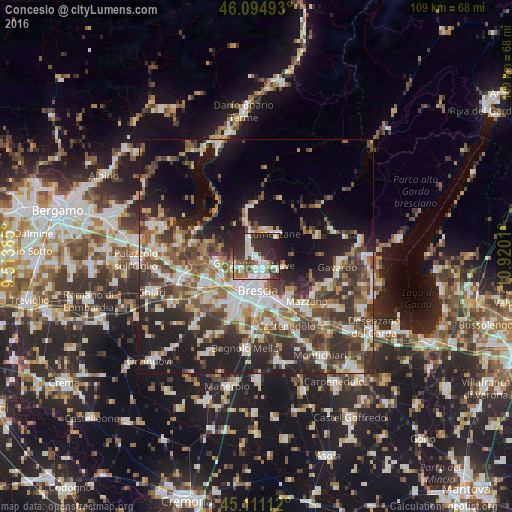
Analysis of Concesio night lights 2016
Square area 10x10 km:
 16.21%
90-99
14.24%80-89
2.73%70-79
4.39%60-69
4.24%50-59
6.52%40-49
7.58%30-39
11.21%20-29
27.27%10-19
5.61%0-9
0%Square area 50x50 km:
6.37%90-99
7.22%80-89
3.11%70-79
3.67%60-69
4.92%50-59
6.52%40-49
6.75%30-39
8.46%20-29
10.85%10-19
15.07%0-9
27.04%Clear (daylight) street map image can be seen on geolist.org.
Map coordinates:
46° 5' 41.7" North, 9° 30' 49.9" East
45° 36' 18.6" North, 10° 13' 1.1" East
45° 6' 40" North, 10° 55' 12.4" East
Some cities around Concesio sort by population:
• Lumezzane
6 km =3.7 mi,  38°
38°
• San Sebastiano
6.1 km =3.8 mi,  30°
30°
• Gussago
5.2 km =3.2 mi,  242°
242°
• Piazza
5.2 km =3.2 mi,  247°
247°
• Sarezzo
6.4 km =4 mi,  345°
345°
• Nave
5.4 km =3.4 mi,  114°
114°
• Villa Carcina
3.5 km =2.2 mi,  331°
331°
• Bovezzo
2.6 km =1.6 mi,  131°
131°
6534249 (p: 11,262)
Sources (retrieved 2019-11-25):
» Earth at Night: Flat Maps 2012, 2016