Dolianova night lights from space
Night Light of Dolianova (Sardinia) from space (Italy) Src. Average luminocity for 10x10km area is 12.2245% and for 50x50km: 15.0466%.
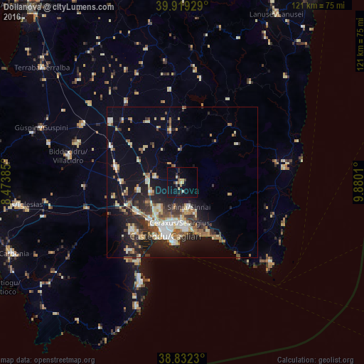
Analysis of Dolianova night lights 2016
Square area 10x10 km:
 0%
0%90-99
1.53%80-89
2.04%70-79
1.87%60-69
1.36%50-59
0.68%40-49
0.85%30-39
2.21%20-29
3.4%10-19
9.18%0-9
76.87%Square area 50x50 km:
1.64%90-99
2.76%80-89
2.02%70-79
1.82%60-69
2.04%50-59
1.51%40-49
1.8%30-39
2.4%20-29
4.85%10-19
9.57%0-9
69.61%Clear (daylight) street map image can be seen on geolist.org.
Map coordinates:
39° 55' 9.4" North, 8° 28' 25.9" East
39° 22' 40.5" North, 9° 10' 37.1" East
38° 49' 56.3" North, 9° 52' 48.4" East
Some cities around Dolianova sort by population:
• Selargius
13.4 km =8.3 mi,  185°
185°
• Monserrato
13.8 km =8.6 mi, 191°
• Sestu
11.4 km =7.1 mi,  219°
219°
• Sinnai
8.6 km =5.3 mi,  165°
165°
• Quartucciu
13.9 km =8.6 mi,  179°
179°
• San Sperate
14.7 km =9.1 mi,  261°
261°
• Maracalagonis
11.2 km =7 mi,  156°
156°
• Settimo San Pietro
9.7 km =6 mi, 175°
2524844 (p: 8,778)
Sources (retrieved 2019-11-25):
» Earth at Night: Flat Maps 2012, 2016