Codigoro night lights from space
Night Light of Codigoro (Emilia-Romagna) from space (Italy) Src. Average luminocity for 10x10km area is 11.5175% and for 50x50km: 8.3452%.
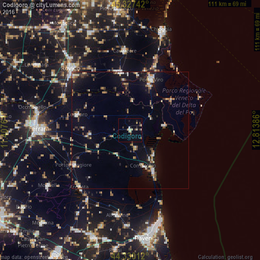
Analysis of Codigoro night lights 2016
Square area 10x10 km:
 0.32%
0.32%90-99
1.9%80-89
2.86%70-79
1.27%60-69
0.32%50-59
0.63%40-49
0.95%30-39
2.22%20-29
2.06%10-19
2.54%0-9
84.92%Square area 50x50 km:
0.75%90-99
1.17%80-89
1%70-79
1.01%60-69
0.74%50-59
1.04%40-49
1.19%30-39
1.11%20-29
1.54%10-19
5%0-9
85.43%Clear (daylight) street map image can be seen on geolist.org.
Map coordinates:
45° 19' 38.7" North, 11° 24' 27.4" East
44° 49' 51.3" North, 12° 6' 38.6" East
44° 19' 48.4" North, 12° 48' 49.9" East
Some cities around Codigoro sort by population:
• Taglio
22.7 km =14.1 mi,  20°
20°
• Porto Viro
23.3 km =14.5 mi, 21°
• Adria
25.2 km =15.7 mi,  350°
350°
• Porto Tolle
21.4 km =13.3 mi,  51°
51°
• Copparo
23.7 km =14.7 mi,  286°
286°
• Comacchio
16.1 km =10 mi,  159°
159°
• Portomaggiore
28.1 km =17.5 mi,  238°
238°
• Taglio di Po
20.7 km =12.9 mi, 23°
3178505 (p: 6,752)
Sources (retrieved 2019-11-25):
» Earth at Night: Flat Maps 2012, 2016