Chiaravalle night lights from space
Night Light of Chiaravalle (The Marches) from space (Italy) Src. Average luminocity for 10x10km area is 45.453% and for 50x50km: 19.7162%.
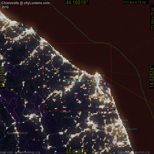
Analysis of Chiaravalle night lights 2016
Square area 10x10 km:
 6.21%
6.21%90-99
8.18%80-89
5.76%70-79
7.58%60-69
5.91%50-59
4.39%40-49
5%30-39
7.73%20-29
28.18%10-19
20.15%0-9
0.91%Square area 50x50 km:
2.59%90-99
3.72%80-89
1.81%70-79
2.08%60-69
2.14%50-59
2.1%40-49
2.29%30-39
3.04%20-29
7.3%10-19
18.83%0-9
54.09%Clear (daylight) street map image can be seen on geolist.org.
Map coordinates:
44° 6' 29.4" North, 12° 37' 19.2" East
43° 36' 4.1" North, 13° 19' 30.4" East
43° 5' 23.3" North, 14° 1' 41.7" East
Some cities around Chiaravalle sort by population:
• Ancona
14.4 km =8.9 mi,  93°
93°
• Jesi
11 km =6.8 mi,  216°
216°
• Senigallia
15.9 km =9.9 mi,  323°
323°
• Falconara Marittima
6.6 km =4.1 mi,  65°
65°
• Osimo
18.1 km =11.2 mi,  135°
135°
• Le Grazie di Ancona
15.3 km =9.5 mi, 90°
• Filottrano
18.5 km =11.5 mi,  173°
173°
• Camerano
20.1 km =12.5 mi,  114°
114°
3178855 (p: 13,465)
Sources (retrieved 2019-11-25):
» Earth at Night: Flat Maps 2012, 2016