Le Grazie di Ancona night lights from space
Night Light of Le Grazie di Ancona (The Marches) from space (Italy) Src. Average luminocity for 10x10km area is 48.2682% and for 50x50km: 15.2061%.
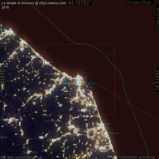
Analysis of Le Grazie di Ancona night lights 2016
Square area 10x10 km:
 13.48%
90-99
10.76%80-89
0.61%70-79
4.85%60-69
4.85%50-59
6.52%40-49
8.33%30-39
5.3%20-29
18.33%10-19
21.21%0-9
5.76%Square area 50x50 km:
2.31%90-99
2.93%80-89
1.4%70-79
1.58%60-69
1.44%50-59
1.64%40-49
1.91%30-39
2.44%20-29
6.48%10-19
13.06%0-9
64.81%Clear (daylight) street map image can be seen on geolist.org.
Map coordinates:
44° 6' 28.2" North, 12° 48' 43.8" East
43° 36' 2.9" North, 13° 30' 55" East
43° 5' 22.1" North, 14° 13' 6.3" East
Some cities around Le Grazie di Ancona sort by population:
• Ancona
1.2 km =0.7 mi,  232°
232°
• Falconara Marittima
9.7 km =6 mi,  286°
286°
• Osimo
13.1 km =8.1 mi,  191°
191°
• Castelfidardo
16 km =9.9 mi,  169°
169°
• Chiaravalle
15.3 km =9.5 mi,  270°
270°
• Porto Recanati
22.1 km =13.7 mi,  147°
147°
• Loreto
19.9 km =12.4 mi,  156°
156°
• Camerano
8.7 km =5.4 mi, 159°
3174915 (p: 6,385)
Sources (retrieved 2019-11-25):
» Earth at Night: Flat Maps 2012, 2016