Camerano night lights from space
Night Light of Camerano (The Marches) from space (Italy) Src. Average luminocity for 10x10km area is 55.1302% and for 50x50km: 17.6549%.
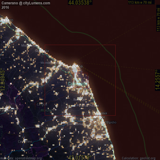
Analysis of Camerano night lights 2016
Square area 10x10 km:
 11.11%
90-99
13.02%80-89
6.51%70-79
5.4%60-69
3.81%50-59
8.41%40-49
8.41%30-39
17.62%20-29
17.14%10-19
6.67%0-9
1.9%Square area 50x50 km:
2.46%90-99
3.55%80-89
1.56%70-79
1.85%60-69
1.5%50-59
1.86%40-49
2.38%30-39
2.72%20-29
7.85%10-19
16.84%0-9
57.43%Clear (daylight) street map image can be seen on geolist.org.
Map coordinates:
44° 2' 7.4" North, 12° 50' 58" East
43° 31' 39.9" North, 13° 33' 9.3" East
43° 0' 56.8" North, 14° 15' 20.5" East
Some cities around Camerano sort by population:
• Ancona
8.4 km =5.2 mi,  331°
331°
• Falconara Marittima
16.4 km =10.2 mi,  311°
311°
• Osimo
7.4 km =4.6 mi,  230°
230°
• Castelfidardo
7.6 km =4.7 mi,  181°
181°
• Recanati
13.8 km =8.6 mi, 179°
• Porto Recanati
13.7 km =8.5 mi,  140°
140°
• Loreto
11.3 km =7 mi,  154°
154°
• Le Grazie di Ancona
8.7 km =5.4 mi,  339°
339°
3181102 (p: 5,368)
Sources (retrieved 2019-11-25):
» Earth at Night: Flat Maps 2012, 2016