Cavezzo night lights from space
Night Light of Cavezzo (Emilia-Romagna) from space (Italy) Src. Average luminocity for 10x10km area is 34.7175% and for 50x50km: 29.4877%.
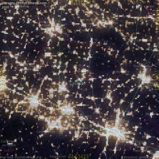
Analysis of Cavezzo night lights 2016
Square area 10x10 km:
 4.29%
4.29%90-99
4.92%80-89
3.49%70-79
2.06%60-69
5.71%50-59
5.56%40-49
3.33%30-39
6.35%20-29
19.84%10-19
43.97%0-9
0.48%Square area 50x50 km:
4.21%90-99
5.54%80-89
2.83%70-79
2.23%60-69
2.66%50-59
3.22%40-49
4.37%30-39
5.04%20-29
10.91%10-19
35.58%0-9
23.4%Clear (daylight) street map image can be seen on geolist.org.
Map coordinates:
45° 19' 53.3" North, 10° 19' 32.8" East
44° 50' 6" North, 11° 1' 44" East
44° 20' 3.2" North, 11° 43' 55.3" East
Some cities around Cavezzo sort by population:
• Carpi Centro
13.3 km =8.3 mi,  243°
243°
• Mirandola
6.4 km =4 mi,  29°
29°
• Nonantola
17.5 km =10.9 mi,  177°
177°
• Crevalcore
15.9 km =9.9 mi,  143°
143°
• Soliera
14.1 km =8.8 mi,  216°
216°
• San Felice sul Panaro
8.6 km =5.3 mi,  88°
88°
• Poggio Rusco
15.8 km =9.8 mi,  22°
22°
• Novi di Modena
11.8 km =7.3 mi,  300°
300°
3179272 (p: 5,464)
Sources (retrieved 2019-11-25):
» Earth at Night: Flat Maps 2012, 2016