Casano-Dogana-Isola night lights from space
Night Light of Casano-Dogana-Isola (Liguria) from space (Italy) Src. Average luminocity for 10x10km area is 50.4227% and for 50x50km: 15.2817%.
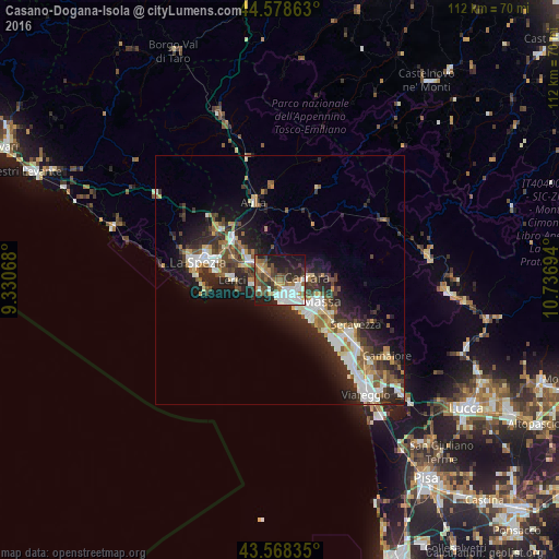
Analysis of Casano-Dogana-Isola night lights 2016
Square area 10x10 km:
 10.15%
90-99
11.06%80-89
1.82%70-79
5%60-69
8.64%50-59
10.45%40-49
9.09%30-39
8.48%20-29
13.48%10-19
19.39%0-9
2.42%Square area 50x50 km:
2.48%90-99
3.02%80-89
1.34%70-79
1.54%60-69
1.65%50-59
2.23%40-49
2.4%30-39
2.63%20-29
6.14%10-19
8.18%0-9
68.39%Clear (daylight) street map image can be seen on geolist.org.
Map coordinates:
44° 34' 43.1" North, 9° 19' 50.4" East
44° 4' 32.3" North, 10° 2' 1.7" East
43° 34' 6.1" North, 10° 44' 13" East
Some cities around Casano-Dogana-Isola sort by population:
• Massa
9.5 km =5.9 mi,  117°
117°
• Carrara
5.1 km =3.2 mi,  85°
85°
• Marina di Carrara
4.2 km =2.6 mi,  171°
171°
• Sarzana
7 km =4.3 mi,  305°
305°
• Marina di Massa
9.9 km =6.2 mi,  143°
143°
• Lerici
9.8 km =6.1 mi,  270°
270°
• Colombiera-Molicciara
2.3 km =1.4 mi, 305°
• Arcola
10.8 km =6.7 mi,  295°
295°
8948761 (p: 6,704)
Sources (retrieved 2019-11-25):
» Earth at Night: Flat Maps 2012, 2016