Rosà night lights from space
Night Light of Rosà (Veneto) from space (Italy) Src. Average luminocity for 10x10km area is 66.9667% and for 50x50km: 41.5806%.
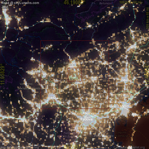
Analysis of Rosà night lights 2016
Square area 10x10 km:
 5.15%
5.15%90-99
10%80-89
10.3%70-79
10.45%60-69
22.42%50-59
31.36%40-49
7.27%30-39
3.03%20-29
0%10-19
0%0-9
0%Square area 50x50 km:
4.14%90-99
6.76%80-89
3.82%70-79
4.92%60-69
6.93%50-59
10.88%40-49
10.8%30-39
10.16%20-29
14.92%10-19
8.99%0-9
17.68%Clear (daylight) street map image can be seen on geolist.org.
Map coordinates:
46° 11' 27.2" North, 11° 3' 29.8" East
45° 42' 7.1" North, 11° 45' 41.1" East
45° 12' 31.6" North, 12° 27' 52.3" East
Some cities around Rosà sort by population:
• Bassano del Grappa
7.7 km =4.8 mi,  339°
339°
• Cittadella
6.6 km =4.1 mi,  164°
164°
• San Zeno-San Giuseppe
6.1 km =3.8 mi,  0°
0°
• Tombolo
8.5 km =5.3 mi,  145°
145°
• Rossano Veneto
3.3 km =2.1 mi,  87°
87°
• Belvedere
1.6 km =1 mi, 148°
• Galliera Veneta
6.1 km =3.8 mi,  129°
129°
• Fontaniva
7.5 km =4.7 mi,  184°
184°
3168970 (p: 12,548)
Sources (retrieved 2019-11-25):
» Earth at Night: Flat Maps 2012, 2016