Cittadella night lights from space
Night Light of Cittadella (Veneto) from space (Italy) Src. Average luminocity for 10x10km area is 64.5227% and for 50x50km: 47.5352%.
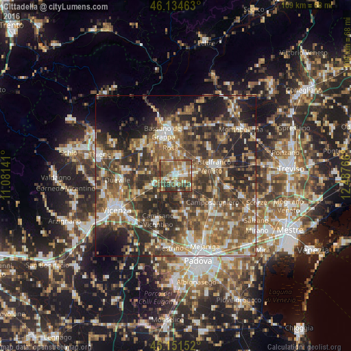
Analysis of Cittadella night lights 2016
Square area 10x10 km:
 10%
10%90-99
9.7%80-89
10.45%70-79
7.12%60-69
11.82%50-59
23.33%40-49
13.79%30-39
10.45%20-29
3.33%10-19
0%0-9
0%Square area 50x50 km:
5.5%90-99
8.24%80-89
4.71%70-79
5.71%60-69
8.15%50-59
12.01%40-49
11.49%30-39
10.36%20-29
15.6%10-19
9.37%0-9
8.86%Clear (daylight) street map image can be seen on geolist.org.
Map coordinates:
46° 8' 4.7" North, 11° 4' 53.1" East
45° 38' 42.8" North, 11° 47' 4.3" East
45° 9' 5.5" North, 12° 29' 15.6" East
Some cities around Cittadella sort by population:
• Rosà
6.6 km =4.1 mi,  344°
344°
• San Martino di Lupari
5.9 km =3.7 mi,  83°
83°
• Tombolo
3.2 km =2 mi,  102°
102°
• Rossano Veneto
6.6 km =4.1 mi,  13°
13°
• Belvedere
5.1 km =3.2 mi,  348°
348°
• Galliera Veneta
3.8 km =2.4 mi,  49°
49°
• Carmignano di Brenta
6.5 km =4 mi,  250°
250°
• Fontaniva
2.6 km =1.6 mi,  244°
244°
3178622 (p: 14,421)
Sources (retrieved 2019-11-25):
» Earth at Night: Flat Maps 2012, 2016