Carapelle night lights from space
Night Light of Carapelle (Apulia) from space (Italy) Src. Average luminocity for 10x10km area is 24.5595% and for 50x50km: 9.2009%.
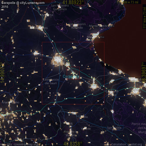
Analysis of Carapelle night lights 2016
Square area 10x10 km:
 2.21%
2.21%90-99
4.59%80-89
5.1%70-79
0.68%60-69
4.08%50-59
1.36%40-49
0.68%30-39
2.72%20-29
6.8%10-19
39.29%0-9
32.48%Square area 50x50 km:
1.02%90-99
1.75%80-89
1.04%70-79
0.87%60-69
1.18%50-59
1.17%40-49
0.82%30-39
1.06%20-29
2.35%10-19
7.89%0-9
80.84%Clear (daylight) street map image can be seen on geolist.org.
Map coordinates:
41° 53' 21.2" North, 14° 59' 26.6" East
41° 21' 49.1" North, 15° 41' 37.8" East
40° 50' 1.7" North, 16° 23' 49.1" East
Some cities around Carapelle sort by population:
• Foggia
15.9 km =9.9 mi,  311°
311°
• Cerignola
20.1 km =12.5 mi,  123°
123°
• Orta Nova
4.1 km =2.5 mi,  160°
160°
• Trinitapoli
33 km =20.5 mi,  91°
91°
• San Ferdinando di Puglia
32.2 km =20 mi,  102°
102°
• Troia
31.4 km =19.5 mi,  270°
270°
• Ascoli Satriano
20.7 km =12.9 mi,  210°
210°
• Stornara
10.7 km =6.6 mi,  143°
143°
3180588 (p: 6,524)
Sources (retrieved 2019-11-25):
» Earth at Night: Flat Maps 2012, 2016