Ascoli Satriano night lights from space
Night Light of Ascoli Satriano (Apulia) from space (Italy) Src. Average luminocity for 10x10km area is 6.4481% and for 50x50km: 6.7946%.
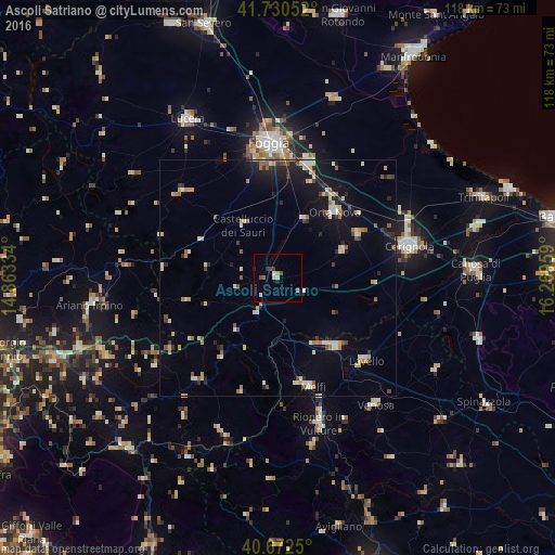
Analysis of Ascoli Satriano night lights 2016
Square area 10x10 km:
 0.32%
0.32%90-99
0.97%80-89
1.95%70-79
0%60-69
1.3%50-59
0%40-49
1.3%30-39
1.3%20-29
1.3%10-19
0.32%0-9
91.23%Square area 50x50 km:
0.48%90-99
1.17%80-89
0.92%70-79
0.71%60-69
0.9%50-59
0.69%40-49
0.58%30-39
0.69%20-29
1.45%10-19
4.54%0-9
87.87%Clear (daylight) street map image can be seen on geolist.org.
Map coordinates:
41° 43' 49.9" North, 14° 51' 48" East
41° 12' 13.1" North, 15° 33' 59.3" East
40° 40' 21" North, 16° 16' 10.5" East
Some cities around Ascoli Satriano sort by population:
• Foggia
28.4 km =17.6 mi,  357°
357°
• Cerignola
28.4 km =17.6 mi,  76°
76°
• Orta Nova
18.4 km =11.4 mi,  40°
40°
• Lavello
25.5 km =15.8 mi,  132°
132°
• Melfi
24.3 km =15.1 mi,  162°
162°
• Troia
27.4 km =17 mi,  310°
310°
• Carapelle
20.7 km =12.9 mi,  30°
30°
• Stornara
19.4 km =12.1 mi,  61°
61°
3182747 (p: 5,518)
Sources (retrieved 2019-11-25):
» Earth at Night: Flat Maps 2012, 2016