Lamporecchio night lights from space
Night Light of Lamporecchio (Tuscany) from space (Italy) Src. Average luminocity for 10x10km area is 33.3197% and for 50x50km: 33.2382%.
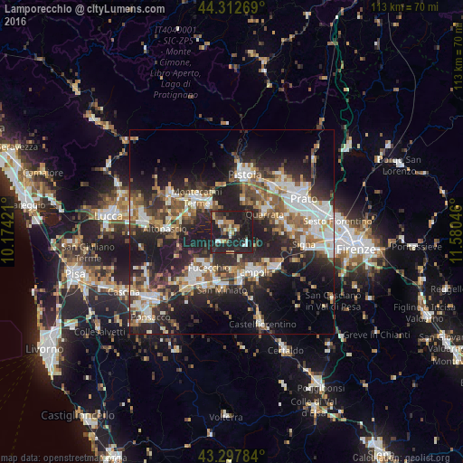
Analysis of Lamporecchio night lights 2016
Square area 10x10 km:
 2.73%
2.73%90-99
4.55%80-89
1.97%70-79
4.39%60-69
4.24%50-59
3.94%40-49
3.94%30-39
5.91%20-29
24.39%10-19
43.94%0-9
0%Square area 50x50 km:
5.78%90-99
6.53%80-89
2.71%70-79
3.39%60-69
4.23%50-59
4.85%40-49
5.27%30-39
5.14%20-29
13.4%10-19
19.12%0-9
29.57%Clear (daylight) street map image can be seen on geolist.org.
Map coordinates:
44° 18' 45.7" North, 10° 10' 27.2" East
43° 48' 26.7" North, 10° 52' 38.4" East
43° 17' 52.2" North, 11° 34' 49.7" East
Some cities around Lamporecchio sort by population:
• Empoli
11.4 km =7.1 mi,  150°
150°
• Fucecchio
10.5 km =6.5 mi,  217°
217°
• Monsummano Terme
8.4 km =5.2 mi,  322°
322°
• Quarrata
9.3 km =5.8 mi,  60°
60°
• Pieve a Nievole
10.3 km =6.4 mi, 322°
• Spicchio-Sovigliana
9.9 km =6.2 mi, 149°
• Cantagrillo-Casalguidi
7.5 km =4.7 mi,  23°
23°
• Capraia e Limite
11 km =6.8 mi,  129°
129°
3175182 (p: 5,179)
Sources (retrieved 2019-11-25):
» Earth at Night: Flat Maps 2012, 2016