Campogalliano night lights from space
Night Light of Campogalliano (Emilia-Romagna) from space (Italy) Src. Average luminocity for 10x10km area is 55.3818% and for 50x50km: 39.3813%.
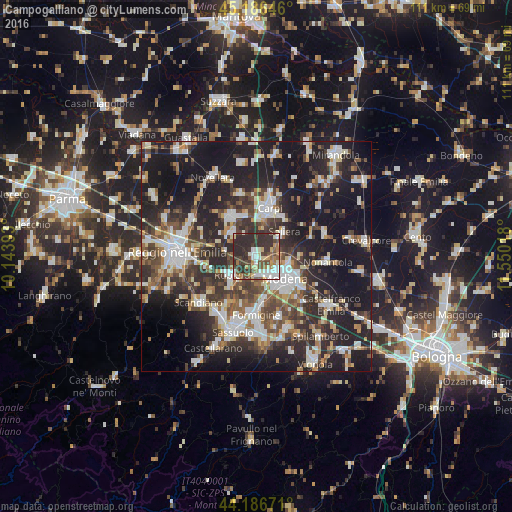
Analysis of Campogalliano night lights 2016
Square area 10x10 km:
 9.39%
9.39%90-99
12.42%80-89
6.06%70-79
3.64%60-69
7.88%50-59
7.27%40-49
10.61%30-39
18.18%20-29
24.55%10-19
0%0-9
0%Square area 50x50 km:
6.6%90-99
8%80-89
3.59%70-79
3.15%60-69
4.2%50-59
5.31%40-49
6.93%30-39
7.81%20-29
15.84%10-19
28.75%0-9
9.82%Clear (daylight) street map image can be seen on geolist.org.
Map coordinates:
45° 11' 11.3" North, 10° 8' 38.1" East
44° 41' 19.5" North, 10° 50' 49.4" East
44° 11' 12.2" North, 11° 33' 0.6" East
Some cities around Campogalliano sort by population:
• Modena
7.7 km =4.8 mi,  126°
126°
• Carpi Centro
10.7 km =6.6 mi,  13°
13°
• Formigine
12.9 km =8 mi,  179°
179°
• Correggio
10.1 km =6.3 mi,  330°
330°
• Rubiera
6.8 km =4.2 mi,  232°
232°
• Soliera
7.7 km =4.8 mi,  49°
49°
• San Martino in Rio
7 km =4.3 mi,  315°
315°
• Rio Saliceto
14.1 km =8.8 mi,  346°
346°
3180970 (p: 6,234)
Sources (retrieved 2019-11-25):
» Earth at Night: Flat Maps 2012, 2016